Good morning, it’s winter forecast photograph request time!
Usual rules:
Must feature winter weather of some description – there is more than one type of winter weather, I try to use what matches the forecast.
Must be the local area.
Can be from any year…as long as it is winter and has weather.
Must be landscape-orientated, ie the width longer than the height. I know plenty of people ignore this when posting on Facebook, which is totally fine, crack on. But I’m not going to use it unless it is landscape-orientated.
Whoever’s photograph I choose will adorn the forecast and also be the cover photograph on Facebook for the next 3 months.
My life is easier if you add them to the Facebook post but you can also e-mail them.
I hope to write it early on Tuesday morning, but depends on work and stuff.…
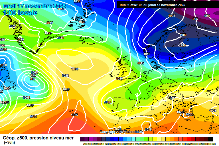
Staying pretty mixed – some sunny days but also some notably wet and windy days too.
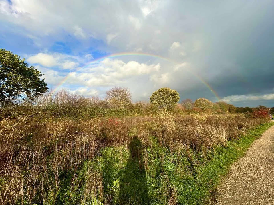
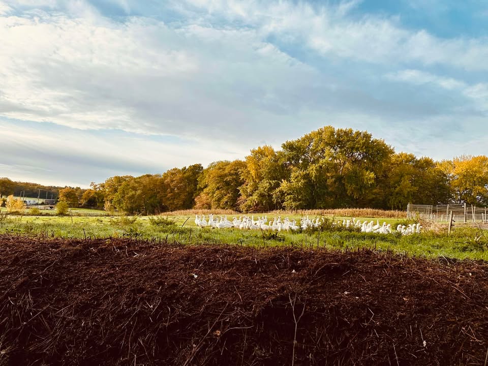
Thanks to Fiona for the photograph – alas I cannot promise you the forecast will be so glorious.
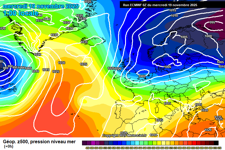
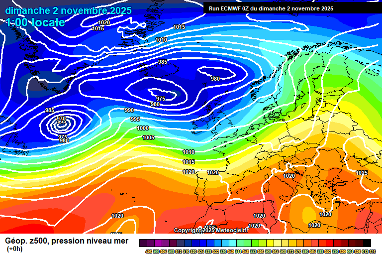
The general background pattern sees a return to a westerly, Atlantic-driven flow, though currently with a milder touch.
Thursday is a cloudy day with bits and pieces of light rain and drizzle – probably more persistent and moderate for later in the afternoon. Breezy but much milder, 13’C. Still some patchy rain in the evening, this clearing to clear skies around or just after midnight. Down to around 7’C.
Friday starts bright with hazy sunshine. The band of high cloud will clear during the morning to un-hazy sunshine, though this will be followed by a band of cloud and showers in the afternoon, still some sunny spells though. Around 12’C and becoming quite windy. Clear skies at first overnight, rain probably arriving in the second half of the night.
Saturday sees a small area of low pressure develop and spread across – details on the timing and amount of rain are uncertain but it will rain at some point. Rain more likely in the morning than afternoon, it could be a couple of hours worth, or it could be a whole day’s worth – some heavy bursts will be mixed in. Likely gusty winds also and around 11’C. The rain could continue into the night, more likely it doesn’t but this is uncertain. Colder air will follow once the rain clears though.
Sunday should be sunny, or mostly so. We’ll lose the mild air so feeling colder – around 6’C. Cloud thickening overnight with rain arriving after midnight, temperatures picking up to around 8’C.
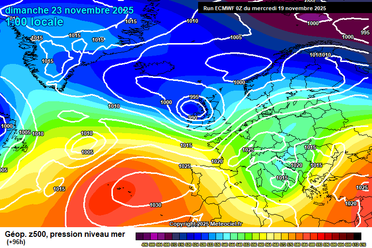
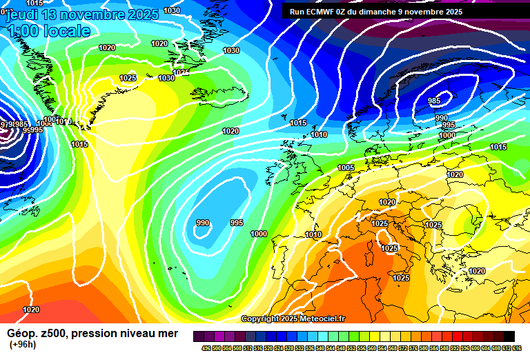
We start December with a re-invigorated Atlantic.
Monday sees heavy rain for much of the day – not always raining, but often, and strong winds too. Welcome to winter. The rain gradually clearing in the evening/overnight, clear spells following and down to around 6’C.
Tuesday sees sunny spells – potentially some showers driven inland by the wind, but uncertain on that aspect. Around 10’C, give or take.
Wednesday probably will be fair, sunny spells, most likely dry, lighter winds – around 8’C.
Further wind and rain probable either Wednesday night or more likely during next Thursday.
Probably Friday and into next weekend looks wet and windy, possibly very windy.
So where’s the high pressure block I was expected for the beginning of December? Good question. And what happened with the sudden stratospheric warming (SSW) event? Also a good question.
The SSW has happened (technically anyway), but what it looks like it is doing is the waves are reflecting from the troposphere back into the stratosphere – and this will strengthen the polar vortex in both layers of atmosphere, and the polar vortex keeps the cold bottled up over Arctic regions, and helps drive wet and windy weather our way.
So, scrap any thinking of cold and dry spells for now – expect wet and windy weather. I’m back to thinking a 1% chance of a White Christmas. Maybe the SSW will have secondary effects down the line, but that’s just speculation.
I will do a winter forecast next week, all being well. Next full forecast will be on Monday. Enjoy…if you can!…
The general overview sees a westerly flow return, with low pressure close by.
Sunday starts wet with a band of heavy rain, but this will fairly quickly clear to sunny spells for the rest of the day, maybe a stray shower but more likely not. Quite windy and reaching around 9’C. Clear spells at first overnight and chilly, down to around 4’C – cloud will thicken with some showery rain arriving before dawn.
Monday will be cloudy for most of the day, some showery rain at first, then some occasional bits of light (ish) rain possible at times afterwards, perhaps some brightness later in the day. Feeling colder again, around 7’C and quite windy at times. Fairly cloudy overnight, though it will tend to break up more in the second half of the night – chilly and breezy, down to around 3’C.
More in the way of sunshine around for Tuesday, though still some cloud at times. A very small chance of a shower. Again pretty chilly in a northerly wind, around 7’C but feeling a bit colder than that. Reasonably clear skies overnight and a frost likely, down to around -1’C. A chance of some fog patches forming too.
Wednesday starts frosty though pleasant with some hazy sunshine. The cloud will gradually thicken during the day as a weather front approaches. Chilly, around 6’C or so. The weather front crosses either in the evening or overnight, bringing some patchy rain, probably on the light side – generally not much rain. Becoming milder and breezy once more, around 10’C.
By Thursday we are back in a milder south-westerly flow. Pretty default weather for the time of year.
Generally it will be cloudy and breezy, with some bits of rain at times – though often not raining. Milder, around 12’C. Cloudy with occasional rain for the first half of the night, but clear skies should spread across in the second half – so down to around 7’C ish.
Friday probably looks reasonably sunny, though a chance of some showers at some point later in the day – uncertain on this aspect. Around 11’C and still breezy.
Next weekend looks changeable – it will probably rain at some point, but also some sunny spells at other times too. Too early for details on when it might rain.
The more likely pattern after that sees blocked conditions with high pressure forming over Europe to our east – stopping low pressure systems from crossing, and likely a mild flow – at least to start with.
Whether the high pressure block will be far enough west to keep us mostly dry is uncertain, though I’d slightly favour it as the outcome.
A cold few days to come, and possibly a wintry surprise or two.
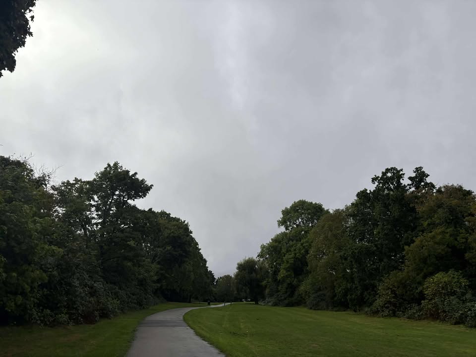
Thanks to Debbie for the photograph.
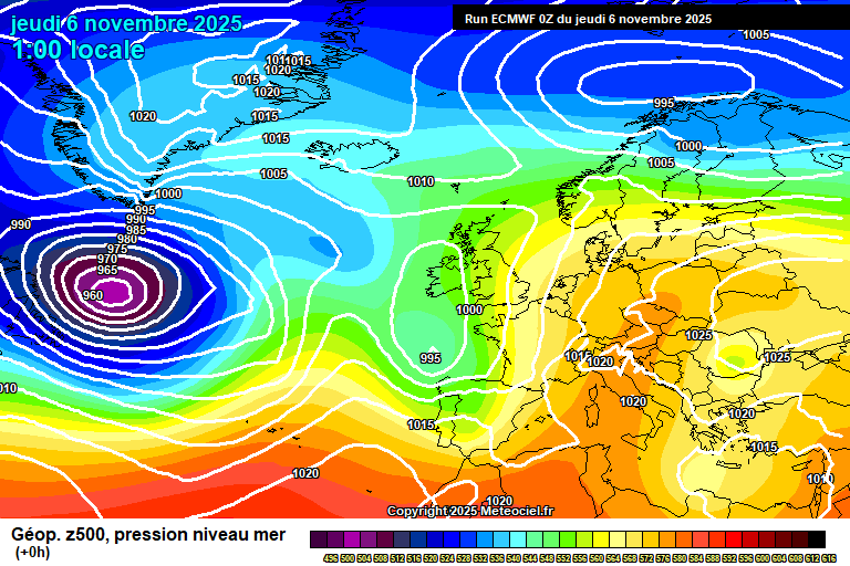
So the big news is that there appears to be a sudden stratospheric warming (SSW) event about to happen – one has not happened in November in my lifetime (I’m 45 now), so I cannot tell you if the outcome would be different than at other times.
What tends to happen an SSW is that the winds reverse in the stratosphere (10-18km above us) – from westerly to easterly, then this filters down to the troposphere 2-6 weeks later, increasing the chance of easterly winds at mid-latitude locations such as Europe.
It’s not an exact science, each event has different effects and the SSW event hasn’t happened yet anyway. But it does mean than there is a higher than normal chance of cold weather (yes, maybe snow) 2-6 weeks after the SSW. And, of course, you know what dates are right in the middle of that!
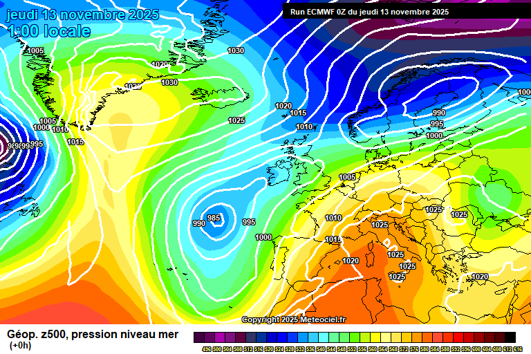
Onto now, and we have our existing cold spell to deal with – high pressure to the west of the UK, low to the east and a northerly wind with notably below average temperatures.
Wednesday starts with a small low pressure crossing – outbreaks of showery heavy rain, which have turned to sleet/snow to our north and this may well persist as it crosses here this morning – perhaps before I’ve had time to click publish. Dry by late morning, some sunny breaks after but plenty of cloud. Feeling cold, 5’C in a northerly wind. Skies clearing overnight and a widespread frost, down to around -2’C.
Thursday starts reasonably sunny but there will be some cloud and one or two scattered showers earlyish morning – more likely of snow than anything else, and falling on frozen ground could lead to a temporary slight accumulation, with ice. Say a 30% chance. After that, a mixture of sunny spells and cloudy spells – probably more cloud overall. Cold in the northerly wind, 4’C. Quite a bit of cloud overnight, probably enough clear spells for a frost, but a close call – down to roughly 0’C. A small chance of fog forming.
Friday looks sunny but cold – perhaps some morning fog but sunny otherwise. We’ll lose the northerly wind so though only 5’C, it won’t feel as cold. A frost at first overnight, down to around -2’C – but temperatures picking up a bit in the second half of the night as a weather front approaches from the west.
Saturday looks mostly cloudy with some bits and pieces of mostly light rain as a weather front crosses, and then fizzles out overhead – perhaps it will stay totally dry. Less cold, 7’C, maybe 8’C. More persistent rain likely in the evening and overnight at times, around 8’C.
By Sunday we have low pressure in control, but it doesn’t look like a return to Atlantic dominance.
Uncertain as to where weather fronts will be come Sunday, as an educated guess maybe we’ll see rain clearing in the morning and followed by sunny spells and possibly showers – but don’t be surprised if it is cloudier with some rain instead. Milder, around 10’C, possibly windy.
For Monday we’ll be back in a northerly-ish flow, though no direct connection to the Arctic this time. Likely quite cloudy with some showers, though some sunny breaks possible. Possible windy, and roughly around 8’C.
The more likely outcome for Tuesday is low pressure sat over us, the winds likely from a chilly direction, fairly cloudy, some showery rain and roughly around 7’C. Not especially high confidence on details though.
The somewhat more likely outcome for Wednesday/Thursday is something on the cloudier side, perhaps a bit of rain and generally quite cool.
There remains a signal for something drier to start December – there was a milder than normal signal too, but this is muted now.
A cold week ahead – much colder than normal for mid-November. Even a small chance of some wintry stuff midweek (though quite uncertain on details).
Thanks to Andy for the photograph.
So it’s an interesting set-up, Storm Claudia to our south – towards Spain/Portugal, and high pressure building towards Iceland/Greenland – which allows for an Arctic blast this coming week.
Sunday starts cloudy – Friday’s weather front is still around though very weak now, just a bit of drizzle at times, and sinking back south. Staying cloudy, or mostly so for most of the day – perhaps some sunny spells by late afternoon. Breezy and around 10’C. Some cloud and some clear spells overnight as the cold air pushes south, around 3’C.
Monday will be a fairly sunny day, some cloud floating around at times but lots of sunshine. However, it will feel fairly cold, just about getting to 8’C but feeling colder than that in the northerly breeze. Clear skies at first though high cloud spreading down in the second half of the night. A frost possible – around 0’C.
Tuesday will be quite cloudy, though some hazy sunshine at times. A band of showers will cross mid/late afternoon – it should be rain but I cannot totally rule out a bit of wintriness mixed in. Chilly, around 8’C, maybe a tad less, and breezy. Probably cloudy with some showers overnight, though some uncertainty on this. Any showers should be of rain, but not impossible for something wintry to be mixed in. Down to around 2’C – though give and take.
Again some uncertainty on early Wednesday, probably cloudy with some showery rain (perhaps some wintriness mixed in) – though this feature may be to our east instead. Afterwards it should gradually brighten up. Notably cold for the time of year, around 5’C and quite windy – so really feeling rather cold. More likely overnight is frosty, though a small chance of some wintry showers. Down to around 0’C – but very give and take.
For Thursday we have high pressure to our west, low to our east – and we start to see the Atlantic go over the high pressure – so milder weather is on its way at this point.
Again quite uncertain on details, other than that it will be cold – around 4’C and feeling colder in the northerly wind. Probably some sunny spells, again a small chance of wintry showers. A frost probable overnight, down to around -2’C.
Friday looks sunny but cold, though at least we will have lost the northerly edge to it. Likely becoming hazy at some point. Around 5’C.
Rain then crosses either Friday night or during Saturday, and it will start to become less cold. Uncertain on how wet it will be at this stage.
Sunday is guesswork at this stage, but average temperatures (around 10’C) and broadly fair conditions is the more likely outcome, though with only low-moderate confidence.
Probably changeable the week after, with rain and wind at times, though some sunnier days too – and temperatures mixed too, some cooler air, some milder air.
Perhaps more broadly drier and mildish for the first week of December.
From unusually mild, to unusually wet – then to unusually cold. Lots going on this week!
Thanks to Tara for the photograph.
The general picture sees the low pressure which has been stuck to the west of us being pushed down towards Spain/Portugal where it will cause flooding issues in places – and notably high pressure developing towards Greenland/Iceland which will allow colder air to sink south in a couple of days time.
Much of Thursday will be reasonably pleasant and very mild, quite a lot of high cloud and some lower level cloud, but there will be reasonable amounts of hazy sunshine – and it will reach 16’C, perhaps even 17’C – quite something for the time of year. By late afternoon rain will start to develop, showery at first but becoming persistent through early evening and heavy. By late evening it will have pushed north of us, but then further rain will develop overnight. A mild night and becoming breezy, around 12’C.
Friday sees the weather front stall across England – at the moment the focus of the heaviest rain looks like it will be through the Midlands, and enough rain will fall (a month’s worth or more, in places) to cause flooding in places prone to flooding in large rain events. Probably we escape the worst, but this isn’t set in stone. So the more likely outcome is outbreaks of heavy rain, occasionally very heavy – though some drier spells too. Later in the afternoon/early evening there is the potential for some very heavy and possibly thundery showers mixed in. Breezy and just about hanging onto the mild weather, around 13’C. Any remaining rain will gradually ease in the evening, remaining cloudy overnight – around 10’C.
Saturday looks mostly cloudy but mostly dry – some bits of light rain/drizzle still possible. Perhaps a little sunshine at times later in the day. Still mild, 13’C and breezy. Remaining cloudy overnight with bits of light rain/drizzle at times, and around 10’C.
By Sunday the wind turns more north-easterly, so a colder flow starts to make its way down here. Still lots of cloud around, some bits of light rain/drizzle at times in the morning – some brighter spells in the afternoon. Around 10’C but feeling colder than it has…because it has been so unusually mild. Some clear spells developing overnight and a chilly night, down to around 3’C – and a chilly wind too.
For Monday we’ll be in a northerly flow.
So a colder feel at around 9’C, but plenty of sunshine – and some bits of cloud at times. Feeling chilly in the northerly breeze. A colder night, potentially getting down to around 0’C – so frost possible, though some uncertainty on whether there will be enough clear spells.
Tuesday looks broadly a mixture of cloudy spells and sunny spells, a chance of a stray shower and around 8’C. A fairly cold night likely, down to around 1’C – some showers possible, more likely of rain but not impossible that they could be a wintry mix.
Wednesday looks colder as the northerly digs in. Some uncertainty on details, more likely good spells of sunshine, but there is a chance of something cloudier with showers, and a small chance they could be wintry. Around 5’C but feeling colder in the northerly wind. A cold night – potentially below 0’C though it depends on sufficient clear skies, and that is uncertain at this stage.
Thursday will remain on the cold side. More likely dry with good spells of sunshine, but a small chance of some showers – and a small chance of those having a wintry nature. Around 5’C. A frost probable overnight with a good chance of sub-zero temperatures.
Probably still on the cold side for Friday, uncertain on weather conditions.
A trend to milder conditions after that is probable – when milder air (with rain) arrives is uncertain, maybe Saturday but more likely Sunday/Monday.
So the latter part of November probably mild with wind/rain at times, and perhaps early December too.
There probably are greater chances of cold spells than previous winters if you go on background signals, but also we are experiencing a warming climate and changing pressure patterns – high pressure over Spain/Portugal does seem to have become more established than normal in recent winters (not sure if this is climate change or just a longer-term trend that will alter at some point), and this tends to stop cold air getting here.
Of course, this coming cold spell is happening when low pressure is over Spain/Portugal. It will be an interesting winter from a forecasting perspective anyway.
At this stage maybe January is the more likely month for cold spells, though there are signs that the latter half of December could feature some colder than normal weather too.
Do keep an eye on the Met Office forecast for Friday if you have plans, especially if you are going to/through the Midlands as there will likely be flooding in places.…
Staying very mild with rain at times in the coming week – perhaps colder the week after, but that’s a long way away.
Thanks to Andy for the photograph.
So we are still in this position where high pressure over Europe is blocking Atlantic low pressure system from crossing the UK, but it’s close enough to send weather fronts across at times.
Sunday is a sunny start for many, though there are a few fog patches around. Cloud will gradually build during the day to make the sunshine increasingly hazy, but it will stay dry. Just about getting to 14’C and breezy later. Showery rain arriving later in the evening, some heavy bursts likely overnight – 12’C.
Monday sees further showery rain, some heavy bursts at times, especially in the morning and around lunchtime. Less showers in the afternoon but still some around – some brightness at times. Around 13’C and breezy. Reasonably clear skies overnight, down to around 7’C.
Tuesday looks bright at times, but there will be plenty of cloud around thanks to the next set of weather fronts. Perhaps some bits of rain in the morning, but the first area should be further to our north – the main band of rain arriving in the evening at some point, perhaps more likely late evening though uncertain on the timing. Very mild, around 15’C and windy. Showery outbreaks of rain continuing overnight, still windy, still mild – around 14C.
Wednesday most likely is a cloudy day with further outbreaks of rain at times. Very mild and breezy, 15’C. Likely cloudy overnight, further rain possible later in the night but uncertain. Around 13’C.
By Thursday the low pressure system to our west is kind of giving up trying to cross the UK, and starts to sink south towards the Azores.
Uncertain on weather conditions at this stage. It will still be very mild, but whether it is a wet day or there is some hazy sunshine to be had – uncertain.
Likewise Friday, the very mild weather hangs on but where weather fronts will be is uncertain. It will likely rain at some point(s) on Thursday and/or Friday, but when it highly uncertain.
Details for next weekend are highly uncertain – colder (and drier) weather is going to try to push down from the north. Will it make it? Not sure.
I’d say Saturday is 65/35 in favour of very mild. Sunday more 50/50. Monday more 70/30 is favour of colder.
So there is a good chance of something colder and drier for the w/c 17th November, at least for a few days – perhaps overnight frost, perhaps fog.
No strong signals after that, though I’d say a return to something more unsettled and milder is the more likely outcome for late November.
So the general picture sees high pressure over Europe trying to block the Atlantic from sending low pressure systems across – and we are on the border, so it looks fairly mixed with neither settled or unsettled weather dominating right now.
We start Thursday fairly cloudy, some bright spells around but also some bits of showery rain around too. The afternoon remains fairly cloudy, but there will be some hazy sunshine at times. Very mild, 16’C, maybe even 17’C. A mild and fairly cloudy night, patchy mist/fog possible later in the night, and a chance of one or two showers also before dawn. Around 13’C.
Friday morning sees a few showers around, perhaps heavy, plenty of cloud though also some brightness. Probably somewhat sunnier through the lunchtime period (give or take) before a band of rain arrives mid/late afternoon, bringing 2-3 hours of patchy rain. Mild, around 15’C and becoming a bit breezier later in the day. Skies gradually clearing overnight, though fog may form in places towards dawn – around 9’C.
Saturday will be a pleasant day once any fog/low cloud in the morning has cleared – uncertain as to what extent fog/low cloud will have developed, and if it has, when it will break up. At best, it could be mostly sunny all day, at worst it will take until early afternoon to break up. Roughly around 14’C. Fairly clear skies overnight, a chance of fog patches forming in the latter half of the night – down to around 7’C, though very give and take on that.
By Sunday we’ll start to see weather fronts edge our way, but for most or all of the day it should be reasonably pleasant for the time of year, some sunshine, some cloud and still mild – around 14’C. Outbreaks of rain probably cross overnight.
Not yet able to do details for Monday, but broadly speaking rain clearing – just how long it takes to clear is uncertain, perhaps in the morning with sunny spells to follow – perhaps it lasts much of the day. Around 13’C or so.
By Tuesday low pressure will be making more of an effort to push our way – but it will still be blocked from doing so.
Day to day details not yet possible for next week, but broadly speaking it will be the same pattern of occasional weather fronts bringing some rain, but often dry.
Often cloudy but sometimes sunny, overnight fog possible. The one detail I’m most confident on is it being mild or very mild, with a southerly flow from Africa so I wouldn’t be surprised to see 17’C reached at some point next week, though broadly around 14’C.
No strong signals for the latter half of November, perhaps some coldish weather for a short spell, though likely to balance out as milder than normal overall. And otherwise fairly mixed, some dry spells, some rain at times.
Fairly unsettled but generally mild/very mild is the theme.
Thanks to Lucinda for the photograph.
The general synoptics see us in a westerly flow, a pretty standard autumnal pattern.
Today (Sunday) will be a reasonable day though, plenty of sunshine, some fair weather cloud, a small chance of a stray shower in the early afternoon period. Around 12’C and breezy. A little chilly at first tonight, down to around 6’C though temperatures lifting in the second half of the night as cloud thickens, with some patchy rain.
Monday morning will be fairly cloudy, some bright spells, perhaps a bit of patchy rain at times. Probably somewhat sunnier in the afternoon. Mild, 15’C, maybe 16’C – generally quite windy. Fairly cloudy overnight, some bits of light rain possible – around 13’C.
Tuesday looks fairly cloudy again, some bits of light rain possible at times, some brightness too. More general showery rain might spread up from the south-west in the afternoon, though uncertain – the track looks slightly more likely to be further to our west as it stands. Still mild, 15’C, maybe 16’C and generally quite windy. Generally cloudy and mild overnight, some bits of rain possible – around 14’C.
More of the same for Wednesday, plenty of cloud but some brightness possible – likewise some showery rain possible, though again uncertain on the track, and more likely focused further west of us. Very mild, 16’C – perhaps a little more thanks to the injection of tropical air via ex-Hurricane Melissa. Cloudy and mild overnight, probably some showery rain – but again details uncertain. Around 14’C.
Lower confidence by Thursday, low pressure still around so further showers possible.
By Friday, I think we’ll start to see high pressure over the continent trying to put a stop to the westerly flow.
Quite a messy picture of neither high pressure or low pressure really having control for Friday and into next weekend – probably at least one weather front will cross during this period with some rain, then otherwise a mixture of cloudy spells and sunny spells, with temperatures roughly around 12’C or so.
Probably we’ll see high pressure having more influence over our weather for the second half of November, though it’s not a very strong signal.