Good morning, it’s spring forecast photograph request time!
Usual rules:
Must feature spring weather of some description – there is more than one type of spring weather, I try to use what matches the forecast.
Must be the local area.
Can be from any year…as long as it is spring and has weather.
Must be landscape-orientated, ie the width longer than the height. I know plenty of people ignore this when posting on Facebook, which is totally fine, crack on. But I’m not going to use it unless it is landscape-orientated.
Whoever’s photograph I choose will adorn the forecast and also be the cover photograph on Facebook for the next 3 months.
My life is easier if you add them to the Facebook post but you can also e-mail them.
I hope to write it early next week, but depends on work and stuff.
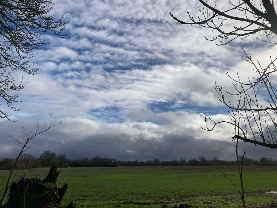
So apparently we had our first day of spring yesterday…alas work got in the way this time. But temperatures should be notably above average for much of the next 2-3 weeks so there are chances of a repeat. And also some cloud, rain, showers at times too.
Thanks to Debbie for the photograph.
We return to a westerly flow, there will be weather fronts but also ridges of high pressure too – and mostly we’ll be on the warmer side of the jetstream.
Today will be mostly cloudy with the odd bit of light rain at times. Becoming quite windy but staying mild, 13’C. Rain will gradually ease eastwards during this evening and overnight, generally light to moderate rain – nothing unusually heavy, and around 10’C.
Friday starts cloudy and damp, with bits and pieces of rain at times. Some bright/sunny spells poking through in the afternoon, perhaps as early as lunchtime – chance of some showers in the afternoon still though, more likely late afternoon. Again very mild, around 14’C and breezy at times. Fairly cloudy overnight with some occasional showery rain – down to around 6’C.
Some uncertainty on details for Saturday, but broadly the morning more likely cloudy with some showery rain, the afternoon brighter with some sunny spells. The uncertainty is mostly over the rain – more likely not much rain and what there is clearing by late morning/lunch, but a chance it could be more organised and persistent and last into early afternoon. Cooler air in the mix, 10’C at best. Clear skies at first overnight – clouding over later with rain probably arriving before dawn, but some uncertainty on the timing. Down to around 6’C.
Most likely Sunday starts with outbreaks of rain – there is a small chance that the weather front fades before arriving, but 90% or so likely there remains some rain. The rain should gradually fade, timing uncertain though broadly speaking we’d be looking at a fairly cloudy afternoon, some limited brightness, perhaps still some patchy light rain. Milder and becoming quite windy again, around 13’C. Mostly cloudy overnight, down to around 7’C.
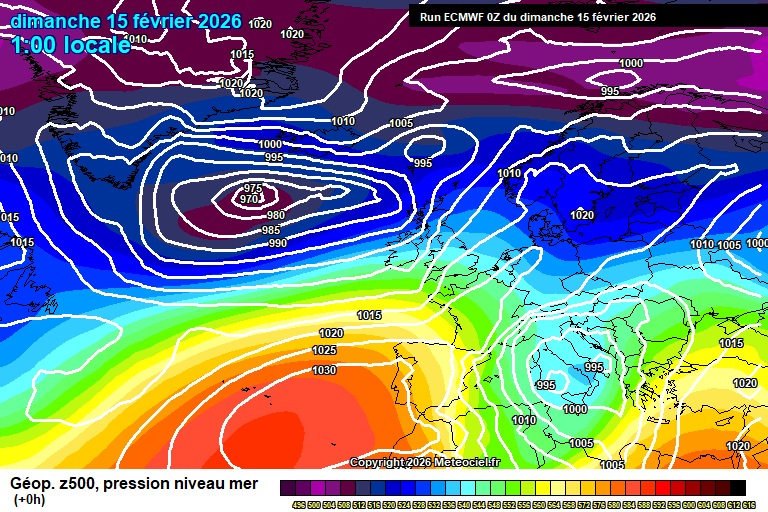
By Monday we see low pressure to our north west and ridges of high pressure both close to our west, and our east.
Again some uncertainty but bright with hazy sunshine is the more likely general theme – a weather front will be trying to cross from the west but will get squeezed by both high pressure ridges as it does. Still mild, around 13’C. The weather front should arrive at some point, perhaps by the afternoon – more likely evening or overnight, and will bring a little rain.
Tuesday probably on the cloudier side with remnants of the weather front still around, some sunny spells possible, the odd light shower too. Around 11’C.
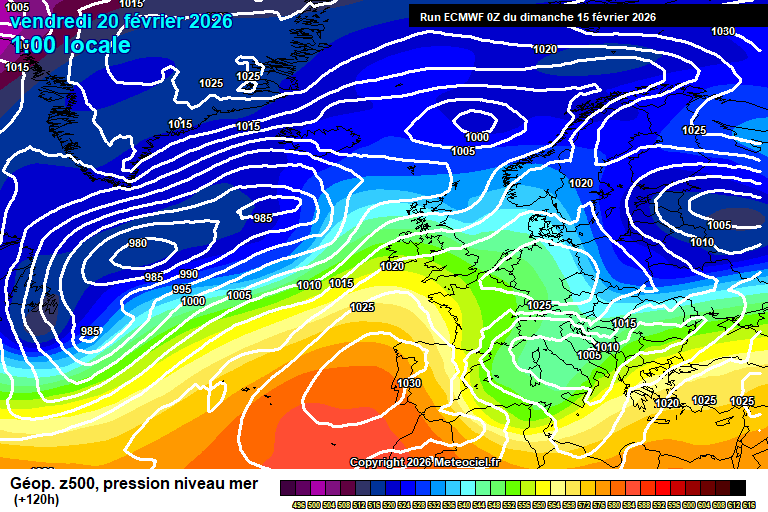
A fair chance of something quite warm and sunny spreading up for the south for next Wednesday/Thursday – still a little bit too tenuous to be confident on.
Maybe a weather front around next Friday (or late Thursday) – and dry/sunny is the more likely outcome for the first full weekend of March – no suggestion yet on temperatures with a broad range possible.
Generally I do expect temperatures for the first half of March to be notably above average, and for it to balance out as drier and sunnier than normal – so you can be hopeful of squeezing in some more 15’C+ days. Overnight frost and fog will be possible, depending on positioning of high pressure.
Annoyingly it looks like a sudden-stratospheric warming event might happen in early March, which if it is confirmed would lead to easterly and northerly flows more likely by late March and early April onwards.
That said, it isn’t the first time this year that one has been modelled – the previous modelling of one just dissipated, and we had one in early March last year…and look how spring turned out. The more likely outcomes in meteorology are just that, and less likely outcomes can happen.
Also annoying timing as it makes my spring forecast more uncertain!…
Well there’s still some cloud and rain in the forecast, but some sunshine and a taste of spring too – our first 16’C day (perhaps a tad more).
Thanks to Christel for the photograph
So the general set-up sees low pressure systems to our north, with high pressure having built strongly over Spain/Portugal to our south, and trying to push a bit further north. Not entirely sure why I’m not packing my work laptop and booking a flight to Seville to enjoy a week of warm sunshine, but hey.
Anyway today starts cloudy with showery outbreaks of rain. This clears around mid/late morning and gradually it will brighten up with reasonable amounts of sunshine in the afternoon, just a small chance of a stray shower – say 10% chance. Very mild, 14’C, might even scrape 15’C, breezy too. Variable cloud amounts overnight, a stray shower possible – down to around 7’C.
Monday starts with some hazy sunshine but cloud will thicken from the west with some patchy rain in the afternoon – mostly light, but the odd heavier burst could be mixed in later. Mild and breezy, 13’C. Mostly cloudy in the evening and overnight, some patchy rain at first but mostly dry from late evening onwards. No lower than around 9’C.
Tuesday starts mostly cloudy. The cloud will gradually break up and the afternoon should be mostly sunny – very pleasant indeed, though some uncertainty as to when the cloud breaks up. Feeling mild in the southerly breeze, around 14’C – maybe a tad more. Clear skies overnight, perhaps some mist/fog patches by dawn – down to around 6’C.
By Wednesday the next low pressure system is ready to push across, but not before we’ve had a taste of spring.
Some mist/fog/low cloud possible at first, and it’s not impossible that it hangs on to spoil the first day of spring – but most likely (90% likely) the sun will be out all day with long spells of sunshine, and it will feel quite warm – 17’C would be feasible. Gosh I’m so excited, but why is it on my office day? Clear spells probably at first, cloudier later – perhaps some light rain by dawn and around 7’C.
Most likely Thursday will be on the cloudy side of things, some bright spells with hazy sunshine possible, also some light showery rain at times. Still very mild, 14’C or so. Rain likely crossing either in the evening or overnight.
More likely Friday is a day of sunshine and showers, breezy and we’ll have lost the warmish air mass – around 11’C or so.
Uncertain for next weekend – anything especially wet seems unlikely, some showery rain possible but also some decent dry spells, perhaps sunshine too. Around 11’C which is slightly higher than average.
Changeable conditions more likely to persist after – a mixture of weather fronts, showers and dry/sunny days, and temperature broadly a little above average more likely, though a couple of colder days could be mixed in. Rainfall amounts likely fairly low in total.
Have a pleasant Sunday and enjoy your early taste of spring!…
Fed up of the cold? You’re in luck. Fed up of the cloud and rain? Maybe book a holiday…though it isn’t a total washout.
Thanks to Isabel who understands the photograph requirements too well!
The general overview sees low pressure centred over the English Channel this morning, with the fairly cold air in situ. But waiting behind is a build of high pressure – so higher pressure and milder air for the weekend, but with the jetstream still broadly heading in our direction, lots of cloud and some rain at times.
This morning starts cloudy, some mist in places, some patchy rain too. The rain will fade during the morning but the cloud will stay, and it will be pretty cold feeling in the breeze – around 5’C. Some spots of drizzle still possible this afternoon but mostly dry. The cloud will break up overnight for a time before thickening again before dawn, as the next weather front approaches – down to around 3’C. The odd spot of drizzle possible before dawn.
Friday morning starts mostly cloudy, perhaps a little hazy sunshine. Showery rain arrives around late morning/midday and will continue on and off during the afternoon, though I stress the showery nature. Becoming quite windy but also milder once the rain arrives – up to around 11’C. Perhaps a bit of sunshine to the end the day, depending on what time the weather front clears. Generally quite cloudy overnight, a shower or a spot of drizzle possible but dry most of the time. Around 9’C.
Saturday will be cloudy and quite windy – but also much milder, up to 13’C, maybe 14’C. Some bits of light rain/drizzle at times, perhaps something more organised in the way of showery light/moderate rain by late afternoon. Cloudy with some rain overnight – though often light and patchy in nature. Around 11’C.
Sunday morning will be cloudy with showery rain. Some uncertainty as to when this clears – perhaps by early afternoon with some sunshine following, or perhaps it continues until the evening. Still windy but still very mild, 13’C, maybe 14’C. Some clear spells overnight, some cloud – a shower possible in the breeze, and down to around 8’C.
By Monday we are still in the same general pattern, high pressure trying to push north but the Atlantic is more in control.
We should at least see some sunny spells on Monday, a fair bit of cloud too – though with temperatures around 12’C or so it should be semi-pleasant. Some rain possible in the evening/overnight though quite a bit of uncertainty at this stage on the track – it could easily be further north.
The more likely outcome for Tuesday is that we are between weather fronts, and still importing this very mild air, so a day of hazy sunshine and around 13’C or so – not quite a taste of spring (for my standards) but not too far away. Not 100% confident – it could be cloudy and wet instead.
Probably we keep the very mild air for Wednesday – weather fronts trying to push across by this stage but uncertain on conditions.
Then by Thursday we start to lose the mild air, by Friday and into next weekend it’s likely pretty chilly once more. Otherwise fairly mixed conditions, rain probable Thursday – drier Friday/Saturday, some showers possible, then maybe rain by Sunday. But this is 10 days away so pretty uncertain on day to day details – but think changeable, some wet days, some sunny days, and you’ll get the general vibe.
And that’s the more likely pattern to start March, though perhaps more stress on the dry/sunny days than the wet days.…
More rain at times, but some sunny spells in between and a trend towards something drier – if broadly pretty cold until next weekend.
Thanks to Isabel for the photograph.
So the pattern has finally changed though it might not especially feel like it at times, notably today. The jetstream has pushed north towards the UK, the Azores high is pushing into Spain/Portugal – the high pressure block to the north-east towards Russia has dissipated. This all means that, sure, it remains unsettled this week but systems can actually clear through, and hence there will be sunny spells when it isn’t raining – instead of those incessantly cloudy skies.
Today will be cloudy with rain until around early afternoon – likely pretty heavy at times, especially mid/late morning. Some sunny spells possibly before sunset, though showers will remain possible. Quite windy at times this morning but the wind will fade. Variable cloud with some clear spells overnight, one or two passing showers in the breeze, down to around 4’C.
Monday sees quite a bit of cloud around, plenty of showers, some heavy – but there will be sunny spells at times too. Quite windy and feeling pretty chilly, around 8’C. Reasonably clear skies overnight, probably too breezy for a frost but a close call – down to around 1’C.
Tuesday sees a ridge of high pressure so a reasonably sunny day, some cloud floating around – a small chance of a light shower, and then generally becoming hazier later in the day as a weather system approaches. Chilly, around 7’C. Cloud thickens somewhat overnight and a fairly cold night – down to around 0’C, perhaps frosty.
Some uncertainty for Wednesday as weather fronts will be trying to progress but without much success. More likely it is fairly cloudy, fairly windy – some bright spells possible, some light rain possible also – and pretty cold at around 4’C. Perhaps instead weather fronts do make more progress and we get something more in the way of rain during the day. Also…a wintry surprise would not be impossible if weather fronts do make more progress. Uncertain overnight – roughly 50/50 between dry and cold, or some mix of rain/sleet/snow.
Thursday also quite uncertain though more likely it’s fairly cloudy, some hazy sunshine and on the dry side of things. Also likely pretty chilly – around 6’C. Frost possible overnight.
By Friday it looks like the Azores High might start pushing towards us, though the jetstream pretty active to our north.
More likely we are looking at something rather cloudy again, perhaps some light rain around, quite windy but also milder feeling – say around 9’C.
Next weekend is probably notably milder, say around 12’C or so, more likely often cloudy, some occasional rain but nothing too much, and perhaps some sunny spells.
The more likely outcome for the week after is a dry and mild start (perhaps even a little pre-spring “faux warmth”) – but becoming somewhat more unsettled once more in the second half of the week.
There are growing signals for March being drier than normal, though still with some short unsettled spells. A fairly recent signal so we’ll see if it remains in a week, and then maybe we can be more confident on it.…
Yep – more rain, but I can also offer you a sunny day, some colder weather at times and an outside chance of some wintriness. Things are changing…
Thanks to Fiona for the photograph – had a fair few cloudy/rainy photographs sent to me and I suspect I’ll get chance to use many of them!
That said the overall pattern is finally about to change – the jetstream has been going through the Mediterranean in recent weeks giving Spain, etc a soaking – and it is now, erm, heading further north towards the UK, from Saturday onwards. But also the high pressure block over north-east Europe/Russia is relenting, so low pressure systems will move through, instead of constantly being sat to our west – ie, there will be sunshine in between spells of rain, sometimes.
A bright start to Thursday, a few breaks in the cloud but it will be a mostly cloudy day with showery rain from roughly mid-morning onwards. Around 10’C. Quite cloudy overnight with a few showers, though a few clear spells too – down to around 4’C.
Friday starts to see cold air moving south. Again a mostly cloudy day, some bright spells possible in the morning, some bits of showery rain at times – more likely in the afternoon. Around 8’C, though an easterly breeze will pick up and it will start to feel colder later in the day. The evening will be cloudy with an increasingly cold feel, some bits of rain still possible (an outside chance of a bit of a wintry mix but it should just be rain) – clear spells in the second half of the night, with a frost forming – down to around -1’C, give or take.
Saturday is your sunny day. Some bits of cloud around, and high cloud will spread across from the west in the afternoon – but otherwise a pleasant if quite cold day at around 6’C. Breezy in the morning, and it will feel cold then. A band of rain will arrive around midnight, a chance of it starting as sleet or snow, or turning to sleet/snow for a short while – though if it does, it will turn back to rain fairly swiftly. Down to around 3’C and quite windy too.
Sunday morning sees outbreaks of rain – sunny spells and heavy showers will follow for the afternoon. Around 8’C and quite windy in the morning, still breezy later. Clear spells overnight, though a shower will be possible in the breeze. Down to around 3’C.
By Monday we are back in our usual westerly flow, with low pressure systems further north than they have been.
Monday looks like a mixture of sunny spells, variable cloud and some showers – around 8’C and breezy. Uncertain overnight – perhaps a frost.
Details becoming more uncertain from here, though Tuesday more likely is a bright day with some hazy sunshine – rain arriving later.
That’s the end of day-to-day details – quite a bit of uncertainty for the second half of next week, some colder air likely around, a mixture of cold dry/sunny days and days with some rain – an outside chance of some sleet/snow mixed in, perhaps some overnight frosts.
So more rain for sure, but also some sunshine. We’ve got through the darkest part of the year, we are past the average coldest part of the year, and the weather pattern bringing all the cloud and rain is being replaced by one with more rain, but also some sunshine at times. I’m taking the positives!
For the last week of February much higher uncertainty than usual, the chance of colder northerly spells with possible sleet/snow is higher than normal, but also the chance of southerly winds with some “faux warmth” is higher than normal – so there could be quite a mixture of conditions – perhaps even a notable storm mixed in too. Though out of that mix I’d suggest colder conditions are more likely.
Have a good end of week – next forecast should be on Sunday morning.…
Yep, plenty more rain to come, though we might squeeze 1/2 colder and drier days at the end of the week.
Thanks to Karen for the photograph.
So the overall picture is the same has it has been for the last few weeks – high pressure blocks to the north-east over Scandinavia/Russia, with the jetstream being forced much further south through the Mediterranean, and large complex low pressure systems dominating especially in western Europe, including the UK.
However, this should change next weekend, and the jetstream will likely track further north towards the UK…which means the rain will be more persistent and strong winds more likely! But…baby steps towards a pattern change.
Today won’t be too bad, quite a lot of cloud, some brightness and some occasional showery bits of rain – more likely later this afternoon and into the evening. Around 10’C. More in the way of showery rain this evening, some showers still possible overnight – down to around 6’C.
Monday again not too bad – quite a lot of cloud around but more scope for some bright/sunny spells than of late, still the odd shower around too. Around 10’C. Further rain arriving around late afternoon/early evening for a fair few hours – gradually fragmenting late evening and overnight. Down to around 8’C and breezy.
Tuesday will be mostly cloudy, some splashes of rain/drizzle at times – more organised rain arriving around early/mid afternoon. Around 11’C and quite breezy at times. Further showery rain in the evening, and showers still possible overnight – down to around 8’C.
Wednesday looks mostly cloudy with occasional bits of showery rain/drizzle – though nothing especially notable likely. Perhaps a bit of brightness at times. Mild and breezy, around 12’C. Rain possible in the evening/overnight though the track is uncertain – more likely further south towards France.
By Thursday we are just starting to see some changes in the pattern – high pressure just nudging into the south of Spain, low pressure finally managing to push across the UK into Europe.
Details a bit more sketchy by this stage due to uncertainty on low pressure track, but broadly quite a bit of cloud around but some sunny spells – and some showers. Around 10’C, give or take. Colder air spreads south overnight – uncertain on details, perhaps skies clearing to give a frost (when was the last one?!), though also a chance instead of some more cloud rain…very small chance of a wintry mix.
The more likely outcome for Friday is that we are in a colder northerly flow, which would mean more in the way of sunshine, outside chance of a wintry shower and temperatures roughly around 4’C. Not a guaranteed outcome yet…but the more likely. Assuming so then likely frosty overnight.
Again assuming Friday happened as above, then Saturday would be similar, sunny spells, some cloud, perhaps a light shower and chilly – around 5’C.
Milder, wetter and windier weather then likely to arrive by Sunday (maybe Saturday night).
And yes, the week after is probably unsettled – with greater chances of heavy rain and strong winds than of late.
Perhaps less rain towards the end of February and beginning of March, though more a reversion to average amounts and some dry days – as opposed to any long dry spells.
I previously mentioned the chance of a sudden stratospheric warming event – this now looks off the cards, and just some minor warming event – unlikely to have any impact on our weather down here, and may just be the stratospheric polar vortex slowly winding down post-winter.
I’m still expecting a broadly meh spring – temperatures average at best, notably cool at times, somewhat showery, somewhat cloudy. But of course there will be some nicer/warmer weather mixed in somewhere…and it is a long time away meteorologically, things can change.
Well I hope you enjoyed your allotted one day of sunshine for the month. I jest, there is a bit more sunshine in the forecast, but there’s plenty more showery rain too.
Thanks to Jessica for the perfect photograph for our current weather.
The general set-up is much as it has been for a couple of weeks now, high pressure blocks over much of Scandinavia and Russia, forcing the jetstream south across the Mediterranean, bringing some really wet weather to Spain/Portugal (again).
The main low pressure trough actually stretches from southern Greenland to north Africa, and across much of Europe – it’s pretty humungous, with various smaller systems and weather fronts affecting different areas at different times. Including the UK.
Thursday will be a mostly cloudy day. Outbreaks of showery rain in the morning, tending to fade towards lunchtime though the odd bit of rain still possible. Perhaps a little bit of brightness at times in the afternoon before further showery rain arrives by later afternoon. Breezy and around 9’C. Further rain in the evening and overnight – not raining all the time, but most of the time. Around 8’C.
Friday again is a mostly cloudy day with some showery rain at times – likely less than on Thursday. Lunchtime to mid-afternoon probably the focus for the more persistent and heavier rain, and perhaps brighter by dusk. A bit milder, around 10’C and a fairly light breeze. Some cloud, some clear spells overnight – one or two showers probable too. Around 6’C.
Saturday will see further spells of showery rain, heavy at times – but also some bright, sunny spells are probable too. Cannot yet put details on the timing of when showery rain is more likely. Around 10’C. Probably dry overnight with some clear spells – down to around 4’C, give or take, a chance of fog forming by dawn.
Subtle changes to the pattern by Sunday as we start to see the Azores High nudge into southern Spain – no effect on our weather on the ground, but if you have a half-term holiday booked in southern Spain/Portugal, then you might be pleased!
For us, well the jetstream should eventually then head north…towards the UK. That’s still a little way away yet though.
Our weather for Sunday…comparatively reasonable, once any early morning fog lifts then sunny spells, variable amounts of cloud, though probably at least a couple of showers at some point too, perhaps heavy. Around 11’C so quite mild – it is on average the coldest point of the year. Mostly cloudy overnight, some showers possible – around 6’C.
Details for Monday a bit more uncertain – anything particularly wet is unlikely, though some showers or showery rain at some point, more likely later in the day, is very possible. And fairly cloudy – around 10’C.
Further bands of rain then likely from Monday night onwards through to Wednesday/Thursday – impossible to put any timing on them at this stage.
More likely next weekend sees further wind and rain, though there remains a smallish chance of something drier/colder – but it would only be a short spell anyway.
Most likely the remainder of February will remain changeable at best, with further wind/rain on a fairly regular basis, though also probably trending milder than normal too.
Oh well. Spring is on the way…but still a fair way away.…
All pretty unremarkable weather, lots of cloud, some rain, some sunshine – roughly normal temperatures but occasionally a bit colder.
Thanks to Christel for the photograph.
The general set-up remains much the same, a large block of high pressure over much of eastern Europe and Russia – which means the jetstream has to go further south through the Mediterranean, and most of the rain hence is towards Spain/Portugal, etc – though we remain on the northern edge of large and complex low pressure systems.
This pattern is going to take some shifting.
Daytime maximum temperatures where the high pressure block is today would be -5’C for Berlin or -15’C for Kyiv. And some high rainfall totals expected across Mediterranean countries – especially western Portugal. Not exactly dry here, but all very ordinary.
Sunday will be cloudy with outbreaks of often light/moderate rain at first, though becoming more persistent and somewhat heavier later in the afternoon/early evening. Around 8’C. The rain gradually clearing east this evening, remaining cloudy with the odd light shower still around overnight – down to around 5’C.
Monday will be mostly cloudy. Some bits of light showery rain possible at times, some brightness also possible – the latter more likely later in the afternoon. Around 8’C, a bit breezier. Cloudy overnight with showery rain arriving by late evening and continuing overnight – around 5’C and breezy.
Tuesday will be cloudy with rain on and off all day. Tending to be light/moderate earlier in the day and more patchy – suggestions that it will be somewhat heavier and more persistent as the afternoon goes on. Picking up a south-easterly wind so feeling a bit colder, around 6’C. The rain gradually moves north overnight, though continues for a fair while – some clear spells possible before dawn. Around 6’C.
Wednesday should be a reasonable day, some cloud around but also some spells of sunshine, and milder in a southerly breeze – around 10’C or so. Some clear spells, some cloud overnight – down to around 4’C, give or take.
By Thursday we see the next large low pressure system heading towards us.
Details a bit sketchier by this point, but more likely dry or mostly dry, more likely on the cloudier side of things, and roughly around 8’C – breezy too. Perhaps some rain overnight.
Friday probably sees some rain around at times, perhaps somewhat colder again though some uncertainty over where the boundary between colder and milder air will be.
Next weekend likely sees rain at some points but also there will be some dry spells too – probably nothing too wet, but low confidence. Most likely a little milder than average, say 10’C – but there is a small chance of it being colder, say around 5’C.
Perhaps something colder and drier the week after – overnight frosts possible and perhaps wintry showery, though low confidence on this.
Higher confidence on it being broadly wetter, windier and milder than normal for the second half of February…assuming no game-changing event such as a sudden stratospheric warming event.
That said, a sudden stratospheric warming event does look more likely than not for mid-February. Too early to know what impact it could have on our weather down here in the troposphere…but impacts would be possible by late February/early March.