Monday 29th December 2025

Fairly cold this week, but becoming colder in the new year – there’s even a small chance of snow.

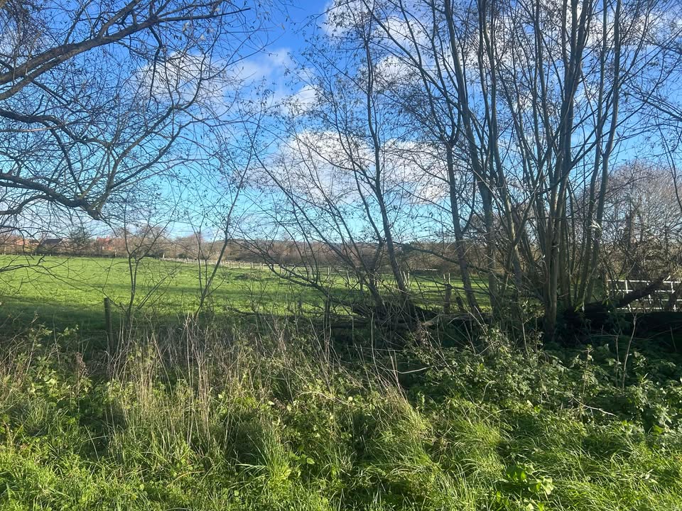
Thanks to Andy for the photograph.

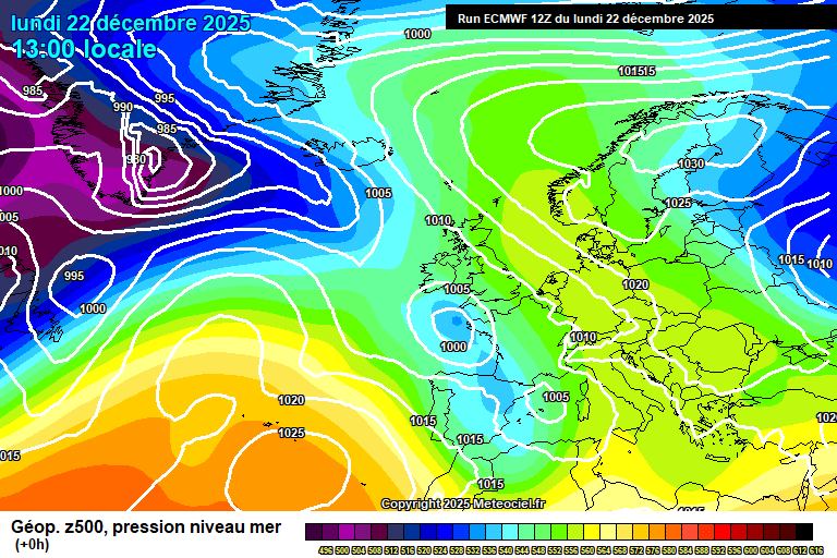
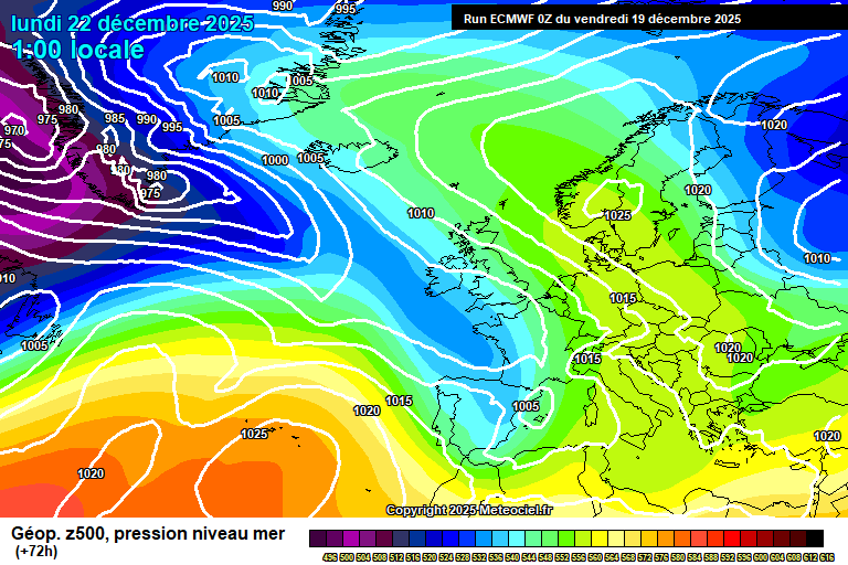
The general picture to start the week sees high pressure to our north-west, we keep the easterly flow though the source isn’t too cold at the moment, so hence nothing especially cold here – the warmer-than-normal North Sea probably also having some moderating influence too.

Monday will be mostly cloudy, some occasional brightness and around 6’C, maybe 7’C in an easterly breeze. Often cloudy overnight though some clear spells, perhaps the odd spot of drizzle also – down to around 3’C.

Tuesday starts mostly cloudy though the cloud should break up somewhat in the afternoon to give more in the way of sunny spells. Perhaps a light shower at some point also. Around 6’C. Some cloudy spells and some clear spells overnight – likely enough clear spells for a frost, and down to around 0’C – but give and take on that. A chance of fog patches by dawn.

New Year’s Eve probably starts sunny, though there is a chance of some morning mist/fog or patches of low cloud. Once any cloud/fog clears then it will remain mostly sunny, just a little bit of cloud around. Colder, around 4’C. Clear skies and frosty at first overnight, down to around -2’C – though cloudier in the second half of the night.

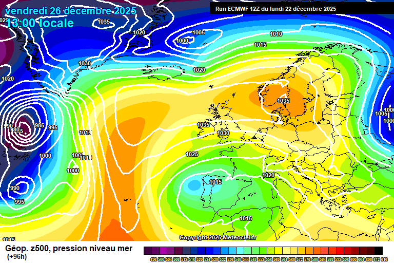
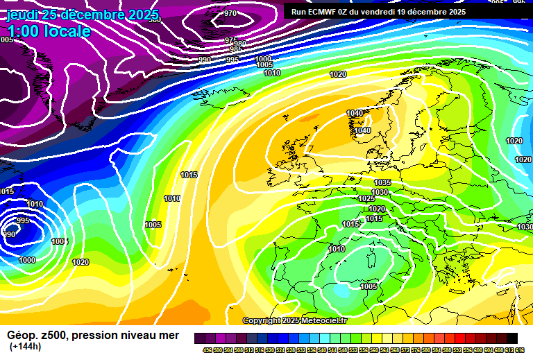
For New Year’s Day, we start to see much colder air spread down from the north.

So mostly we’ll only get cloud from the weather front on New Year’s Day, perhaps a bit of showery rain but more likely it will have all faded by time it gets this far south. Some bright spells probable too. Around 4’C, maybe 5’C and becoming breezier. Some clear spells likely overnight, a frost possible – roughly down to around 0’C.

By Friday there is more uncertainty on details, but broadly speaking a fairly sunny day, some cloud at times – suggestions of a little feature spreading down from the north in the afternoon which would give some showers, perhaps with a wintry mix, but still too early to be sure on this. Feeling colder in the northerly breeze, though still around 4’C. Cold overnight with a frost very likely – it should be down to around -3’C, though some give and take on that. A small chance of a stray snow shower.

Saturday most likely is a cold but sunny day, with only a small chance of a stray snow shower. Around 2’C. However, there is a small chance instead that a weather front spreads up from the south – if it does then a spell of snow would be likely. It’s no more than a 5% or so chance as it stands, but because it would cause disruption, it is worth mentioning – if you have plans, do keep an eye on forecasts. Likely frosty overnight, down to around -3’C, a stray snow shower not impossible.

Sunday again looks cold but mostly sunny – around 2’C. Not impossible that there would be some kind of feature to bring some wintry showers at some point, but impossible to say right now. A sharp frost likely overnight once more.

Next week likely starts cold once more, but probably (with very low confidence), the westerly flow will return and temperatures will recover to normal or just a little below normal – precipitation should then be of rain, though certainly possible that the transition could see some snow mixed in.

Certainly possible that it just remains mostly cold and mostly dry.

So an interesting and cold start to 2026 ahead – I’ll be back on either Thursday/Friday morning, depending on how bad my New Year’s hangover is!…

Monday 22nd December 2025

Mostly dry and becoming somewhat colder for Christmas week.

Thanks to Tracy for the photograph.

So the general overview sees high pressure developing over Scandinavia, with an easterly flow setting up – and the current diminished low pressure moving south.

Tonight will be mostly cloudy, a little light rain/drizzle possible at times, perhaps some mist too. Down to around 7’C.

Tuesday will be dry but cloudy. The easterly breeze starting to make it feel somewhat colder, around 7’C. Remaining cloudy overnight, down to around 4’C.

Christmas Eve should see more in the way of sunshine – still some cloud floating around at times. A bit colder, around 5’C and feeling colder than that in the wind. Skies tending to clear overnight, likely too windy for a frost – down to around 1’C.

Christmas Day should be mostly sunny – but cold. 4’C and fairly windy – so feeling colder than it will register on the thermometer. Perhaps some cloud later in the day – a very, very small chance of a wintry shower but highly unlikely. Some cloud probable overnight, though clear spells also – touch and go on a frost, down to around 0’C but still probably too breezy.

High pressure remains in control for Boxing Day, and the easterly flow remains – though not tapping to anything especially cold over Europe.

It will remain dry for Boxing Day – uncertain on cloud/sunshine amounts, though more likely a mixture of cloudy and sunny spells during the course of the day. A bit less cold, around 5’C and the breeze lessening. Uncertain on cloud amounts overnight – frost possible if skies are clear.

Again Saturday is uncertain on cloud/sunshine amounts – probably a mixture of cloudy and sunny periods once more. Around 6’C. Cloudy spells more likely overnight.

Sunday probably on the cloudier side of the spectrum, though temperatures nudging up a tad more to around 7’C. Still some uncertainty, so I cannot rule out something on the sunnier side of the spectrum.

High pressure likely, if not certainly, remains close by next week.

More likely we’ll keep with the average temperatures and a fair amount of cloud – perhaps some mist/fog at times, possibly some occasional light rain/drizzle.

But there is a small chance instead that high pressure moves further north-west and we get a more northerly flow with some wintry showers. I’d say this is a 20% chance at best, but something to have on your radar if you have plans for New Year.

Probably it stays mostly dry and settled for at least the first week of January, perhaps two weeks.

So I wish you all a very Merry Christmas!

I doubt I’ll do another forecast until next week – thanks to the weather for settling down and being boring, it is appreciated.…

Friday 19th December 2025

After a proper soaking yesterday, its time for things to gradually somewhat drier and a bit colder.

Thanks to Phillipa for the photograph.

So the general set-up right now sees us remain in the westerly flow, though not for long.

Today will be mostly sunny. A bit of cloud around at times, a bit of high cloud around at first – but a very pleasant December day otherwise. Around 10’C though still breezy. Reasonably clear skies overnight, down to around 3’C – a small chance of some fog patches forming by dawn.

Saturday looks a reasonable day, once any fog patches have cleared. Reasonable amounts of sunshine, some cloud possible at times and a 25% chance of a shower drifting up from the south. Around 9’C. Cloud thickening overnight with some bits of showery rain, still around 9’C.

Sunday sees a decaying low pressure over the UK – generally cloudy with some showery rain at times. Around 10’C. The rain probably more persistent in the evening and the first part of the night, though some uncertainty on this, breezy too. Still around 10’C.

By Monday we start to see high pressure building over Scandinavia, and also attempting to build to the west over the Atlantic – which starts to push our low pressure down into Europe.

Generally we’ll be looking at a cloudy or often cloudy day, with some bits of light rain possible. Around 10’C or so. Probably cloudy overnight, some light rain again possible, around 7’C.

For Tuesday the wind starts to swing to a more easterly (ish) direction, so feeling cooler. Uncertain on cloud amounts – it could be a sunny day, it could be a cloudy day (with some light rain) – or somewhere in between. Cloudy seems more likely though. Around 7’C, give or take. Probably cloudy overnight with some light rain possible, around 5’C.

The more likely outcome for Christmas Eve is an easterly flow, cloud more likely than sunshine and temperatures around 6’C – though feeling colder in the chilly wind. If the cloud clears overnight, a frost will be possible.

For Christmas Day itself, probably we are in an easterly flow.

Uncertain on cloud/sunshine amounts at this stage, though it will feel fairly cold at around 5’C and in that easterly wind.

I still cannot totally rule out a White Christmas, the positioning of the high pressure remains subject to change, and it plausibly could orientate itself a bit further north, which could allow for some wintry showers – say a 7% chance now.

High pressure likely remains close by between Christmas and New Year, probably even into the first week of January, which means generally it should be on the cold side of the spectrum, overnight frosts very possible (assuming a lack of cloud), fog possible – sunshine/cloud amounts uncertain.

Very possible again that high pressure could orientate itself to allow for some wintry showers from the east at some point, or low pressure systems from the west could push up against colder air and bring some snow or rain/snow mix during this period. Impossible to say at this stage…but do keep an eye on the forecasts if you have travel plans after Christmas (and try to ignore the clickbait articles).

Have a good weekend, the next forecast will probably be on Tuesday morning, maybe on Monday, we’ll see.…

Tuesday 16th December 2025

Fairly mild with some further rain this week, drier and probably colder in time for Christmas.

So the general picture sees high pressure to our south-east which has kept us dry recently, being pushed away as weather fronts spread across from the west.

Tuesday starts mostly cloudy with showery rain – some heavy bursts possible but it’ll be fairly hit and miss, not much rain in the grand scheme of things. A few splashes of rain still possible early afternoon but it will become dry, mostly cloudy though some bright spells possible later in the afternoon. Mild in the morning, around 11’C, a little lower once the rain clears. The remaining cloud slowly clearing overnight, though fog will then form fairly widely, perhaps frosty too – down to around 1’C.

Wednesday starts foggy for most, though not necessarily everywhere. This will slowly break up, some hazy sunshine possible but still lots of cloud as the next weather front approaches. Some bits of light rain possible in the afternoon. Around 9’C and becoming quite windy later. Rain crossing during the evening and overnight, likely cleared before dawn. Fairly strong winds for a time, and temperatures around 10’c.

Thursday probably starts dry, or with patchy rain at most, but further heavy and persistent rain will spread up from the south/south-west for pretty much all day – a fair soaking. Strong winds too and around 11’C. Still some rain around in the evening but showery by this stage and it will fade out to leave a dry night – around 7’C.

Friday looks a sunny day, maybe some high cloud still in the morning but otherwise pleasant for the time of year. Around 9’C, maybe 10’C. Fairly clear skies overnight, down to around 5’C.

By Saturday there are notable changes – high pressure develops to the west in the Atlantic, but also the European high pushes north too, which leaves the low pressure trapped over the UK.

Saturday probably will be fine, the weather front will likely be to our west – so we’ll have hazy sunshine and temperatures around 9’C or so. Uncertain overnight.

Sunday probably sees some rain or showers as low pressure moves closer, though also further south – some uncertainty on this though.

Highly uncertain after that, though an easterly (ish) flow and something generally drier (some bits of rain possible) and somewhat colder is the slightly more likely outcome through Christmas week – not impossible we could go full-on easterly mode with wintry showers later next week/weekend, though that is only a small chance.

A White Christmas is maybe a 4% chance now…creeping up a tad but still highly unlikely. If I were forced for a forecast for Christmas Day, then cloudy, maybe some drizzle and chilly – around 6’C.

Colder and drier than normal seems the more likely outcome for late December and early January – fog/frost very possible.

Next forecast should be on Friday morning, all being well – busy time of year!…

Friday 12th December 2025

Some rain ahead, but high pressure over Europe impeding progress of weather fronts more than previously expected.

Thanks to Christel for the photograph.

So the general overview sees an active Atlantic on a fairly strong jetstream, but high pressure to the south-east over Europe is deflecting it away somewhat from us…somewhat, anyway.

Friday starts cloudy – a weather will gradually cross during the morning, bringing mostly light and patchy rain/drizzle, maybe a little more moderate at times. Mostly dry this afternoon, perhaps still a bit of drizzle at first, then mostly cloudy for the rest of the day. Still mild, around 12C. Skies gradually clearing overnight, a chilly night – down to around 2’C, a frost possible in more sheltered spots, perhaps some patches of fog by dawn.

Saturday morning will be sunny (a small chance of some fog patches early on though in more sheltered spots). Skies becoming hazier in the afternoon. Around 10’C. Cloud gradually thickening overnight, down to around 3’C.

Sunday will be fairly cloudy though bright, with hazy sunshine at times – the high pressure block still not allowing weather fronts across (not what I expected a few days ago). Around 10’C or so, maybe a tad milder than that, and becoming breezy later in the day. It should stay dry overnight, though the weather front to our west edging closer – around 8’C.

Still a very similar set-up for Monday, though the weather front will be edging closer.

So often cloudy but probably staying dry on Monday, perhaps a bit of light rain. Around 11’C and breezy. The weather front probably finally crosses overnight, bringing some showery rain.

Tuesday probably sees further showery rain as the weather front very slowly edges east. Around 8’C. Fog and/or frost possible overnight.

Wednesday then probably sees another weather front crossing, bringing some showery rain – timing TBC. Around 9’C or so.

Early suggestions of a notably deep area of low pressure later on Thursday or perhaps Friday instead, which could bring some disruptive winds, and further heavy rain – not guaranteed yet, but something to watch out for if you have plans.

Very low confidence but possible it calms down after that with something a bit colder in time for Christmas. Consider the chance of a White Christmas now at 2%.…

Sunday 7th December 2025

More rain, though milder and there are two pleasant days in the forecast.

No suitable photograph this week – even I keep forgetting to take any on my adventures around London.

The general overview sees a westerly flow, with various low pressure systems heading our way, some slowly, some quickly – on a strong jetstream which will become stronger thanks to a plunge of cold air in North America this week.

Today will be cloudy with patchy rain, often light though sometimes more persistent and moderate. Much milder at around 13’C, though also rather windy this afternoon. Skies will clear this evening, around 9’C – though becoming cloudier again before dawn.

Monday starts mostly cloudy, perhaps some brightness but also some patchy light (ish) rain possible from a weak weather front. Some limited bright/sunny spells in the afternoon for a time before further showery rain spreads up from the south-west perhaps by mid/late afternoon though more likely arriving around early evening – showery at first so it will be hit and miss for a time. Very mild, 13’C, maybe 14’C and breezy. The showery rain will become more persistent and fairly heavy overnight, the winds fairly strong and around 11’C.

Tuesday sees further showery rain – more so in the morning, some heavy bursts possible – some rain still around in the afternoon, though generally lighter. Very mild once more, 13’C, maybe 14’C, with strong winds too, especially in the morning and through lunchtime. A lot of high cloud overnight, around 8’C.

Wednesday sees a ridge of high pressure developing, a reasonably pleasant day for December, decent sunny spells, some cloud around, and 12’C. Fairly clear skies overnight, down to around 6’C.

Thursday should hang onto the pleasant conditions, more in the way of sunshine though tending to become hazier as the day goes on, as weather fronts approach. Around 11’C. Rain might spread across overnight – uncertain on the timing.

By Friday our little ridge of high pressure gets shunted out of the way as the jetstream strengthens and starts to push weather systems across again.

Highly uncertain on detail for Friday – we know a weather front will be trying to push across, perhaps it did overnight and Friday is dry ish, perhaps it is still to our west and Friday is cloudy – or perhaps it will be overhead, slowly pushing some rain across.

Once this weather front crosses, this will open the doors to further wind, rain and showers during next weekend – timing uncertain. Remaining mild though.

The following week most likely is unsettled, further rain, showers and strong winds at times. Temperatures mostly on the mild side, though short somewhat colder air might be mixed in at times.

Speak later.…

Thursday 4th December 2025

A pretty unsettled spell ahead with wind and rain dominated.

Thanks to Tara for the photograph.

The general overview sees a queue of low pressure systems, though the one nearest Canada is going to become the dominant one and absorb the others.

Thursday starts cloudy with showery rain – clearing around 1pm, give or take. Some sunshine will follow. Around 8’C though chillier once the rain clears. Also quite windy with a short spell of strong winds probable around lunchtime. Mostly clear skies overnight and we might just scrape a frost, down to around 0’C – a chance of fog patches by dawn also.

Any fog patches lifting fairly quickly on Friday morning to sunny spells, though as the morning goes on it will become hazier. The cloud will continue to thicken with outbreaks of rain arriving around 3/4pm, maybe 5pm. 8’C, becoming windier as the rain approaches. Rain crossing in the evening, likely heavy at times, if not very heavy, and a few heavy/very heavy showers will follow overnight. Strong winds in the evening, fading after the main rain band clears, still around 8’C.

Saturday looks quite showery, the showers possibly heavy/very heavy at times, more so in the morning, fewer and less heavy showers around in the afternoon. Generally quite cloudy, though some sunny spells. Breezy but milder, 11’C. Clear spells at first overnight but cloud and rain spreading across after midnight. Around 8’C.

Some uncertainty on details for Sunday, but broadly speaking probably on the cloudy side, some rain probable in the morning, brighter skies possible in the afternoon – but I wouldn’t want to promise it. Milder, around 12’C or so. Showers possible overnight.

We should get a brief rest on Monday as a ridge of high pressure pushes up – but the next low pressure systems will be on their way.

So Monday is probably drier and brighter – though I wouldn’t want to 100% promise this right now, as the next low pressure system will be on its way. Milder, around 12’C. Most likely rain arrives overnight, likely heavy and persistent – with strong winds.

Tuesday, again some uncertainty due to the development of Monday’s low, but probably will see further rain at times. Mild, around 13’C. Strong winds very possible.

After that, we probably see the high pressure block continue to develop further east – weather fronts will still get through, but with less heavy and patchier rain – think longer dry spells with some rain at times.

Likely remaining mild, say 11’C by day, and generally quite breezy. Overnight frosts unlikely.

Enjoy the end of the week and your weekend.…

Winter Weather Forecast 2025/26

Welcome to my winter weather forecast 2025/26 for Reading and the surrounding areas, though also can probably apply more widely.

Starting with the usual caveat that seasonal forecasting is experimental, some of this will be wrong – a successful forecast would see more right than wrong overall.

Plus events happen that shift weather patterns, such as the recent technical sudden stratospheric warming, which initially increased the chance of cold weather patterns, but as it played out, it seems it has enhanced the usual westerly Atlantic-driven pattern instead. This forecast, at least for December/January is significantly different from what I was expecting a couple of weeks ago.

And thanks to Margaret for the photograph.

Background Signals

La Niña is in evidence though weak – this tends to mean colder flows are more likely in late autumn/early winter (as we had in mid/late November) westerly flows more likely in late winter.

On the flip side, the Quasi-Bienniel Oscilation is in easterly mode, which reduces the chance of westerly flows.

The SSW event has been what is known as a reflective event, and the primary effect of this is to strengthen westerly flows – so this will likely impact over the next few weeks.

The Madden Julien Osciliation is currently in a phase which may lead to colder weather patterns in late December, but possibly the SSW overrides this.

The stratospheric polar vortex is on the weak side, despite strengthening after the SSW – and my guess is that it won’t be so strong this year, which could lead to a lessening of westerly flows.

Overall, one has to conclude that the background signals are rather conflicting this season.

December

The first half of December looks fairly unsettled, wind and rain some days, brighter on others though some showers possible. Temperatures often around average, sometimes mild.

Around, or just after mid-December, high pressure may develop over or close to the UK, allowing for some drier weather, perhaps colder – overnight fog/frost possible. Cloudy skies more likely than sunny skies during the day.

However, this is quite uncertain – and weather fronts probably would occasionally push through bringing some, but not a huge amount of rain.

Suggestions that it becomes more broadly unsettled and milder by the end of the month.

Overall I expect above-average rainfall, above-average temperatures, around or slightly-below average sunshine amounts.

Confidence level of 70%, though lower for the second half of December.

January

More likely, January starts on the unsettled side with wind and rain at times – temperatures broadly on the mild side, though some short colder spells of north-westerly winds very possible.

My guess is that around mid-month, perhaps a little earlier, we start to see high pressure to the east blocking progress of the weather systems. So it becomes often dry, often cloudy – perhaps overnight fog, possibly some overnight frost. Temperatures generally around average though some chilly weather at times.

Perhaps more unsettled towards the end of the month as low pressure systems try to break down the block.

Overall I expect slightly above-average rainfall, slightly above-average temperatures and slightly-below average sunshine amounts.

Confidence level of around 50% – too many conflicting background signals to be really happy with this, there certainly is potential that it could be wetter for the whole month.

February

Low confidence for February though a fairly mixed start is perhaps the more likely outcome, with high pressure further north-east – not impossible there could be some colder weather from this set-up.

After that, more likely high pressure regains control, though in what position is uncertain – so expect drier weather, hopefully more sunshine, but possibly on the cold side at times.

Overall I expect slightly below-average rainfall, around average temperatures and around or maybe slightly-above average sunshine amounts.

Confidence level of 20% – I’m wary both of La Niña seasons involved unsettled Februrys so it could be much wetter than normal – but also the weaker stratospheric vortex could be disrupted by another SSW, which could be more likely to provide cold/wintry weather.

February really could be anything.

Summary And Spring Thoughts

Quite a hard forecast this season, especially for January and February – both months could easily be very wrong. I will update in the usual forecasts when things change.

Very early to be thinking about spring, but I’d currently suggest March and April more likely to see some colder weather at times on current weather patterns. No strong signals on rainfall amounts this far ahead, but broadly around or slightly-below average would be my guess. Maybe time to plan that spring holiday!

In summary, wetter earlier in winter, somewhat drier and colder in late winter though becoming highly uncertain.…

Monday 1st December 2025

Staying mixed this week, though today is the wettest day.

No photograph this week as I only have sunny ones in the inbox…and that doesn’t feel right looking out the window right now.

So the general overview sees a westerly flow, the Atlantic very much in charge.

Today sees rain on and off all day, sometimes quite heavy, sometimes on the light side too. Strong winds, 40mph gusts possible but milder, 11’C. Rain continuing until late evening, maybe midnight at a push – clear spells following. Down to around 6’C once the rain clears, and the wind will ease too.

Tuesday morning looks reasonable sunny, some cloud. Some showers will likely move inland for a time in the afternoon, a 70% chance of catching one or two. Breezy, around 10’C. Fairly clear skies overnight, perhaps a shower – down to around 3’C.

Wednesday looks reasonably sunny, some cloud around and a small chance of a passing shower. Around 9’C, maybe 10’C and breezy at times. Becoming cloudy overnight as a weather front crosses, some rain in the second half of the night. Down to around 6’C, though a little milder during the rain.

By Thursday the next low pressure is moving in, though being somewhat disrupted in its progress by high pressure to the east.

Overnight rain potentially still around first thing in the morning – some uncertainty over how quick it clears, but it will then be followed by sunny spells and scattered showers. Around 9’C and breezy. Further showers possible overnight though some uncertainty.

Lower confidence on details for Friday, probably we are in between low pressure systems, so dry weather is more likely – uncertain on sunshine/cloud amounts. Around 8’C. Rain then probably crosses overnight.

Details uncertain for the weekend, but low pressure will be close by, so very likely it rains at some point (or points) – but when it TBC. Temperatures still around average, say 9’C give or take.

Likely staying very mixed after, rain some days, brighter others, perhaps some milder air mixed in at times.

Have a respectable week, hopefully I will get time to do the winter forecast tomorrow!…