Sunday 12th April 2026

Showery vibes for the first few days giving way to something drier later next week.

Thanks to Karen for the photograph – doesn’t quite match the weather but the only one left in my inbox!

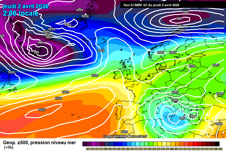
The general overview sees low pressure to the north-west of Scotland, driving a more showery regime for a few days.

Sunny spells to start Sunday but showers will develop during the morning, becoming more frequent in the afternoon and most places catching a few, probably heavy, a small chance of hail/thunder mixed in. Around 14’C and breezy, especially in showers. Showers fading this evening, reasonably clear skies overnight and pretty chilly – down to around 2’C.

A chance of some mist/fog patches around dawn, but they will quickly lift and leave sunny spells. Again cloud bubbling up during the morning with some showers breaking out – but fewer than on Sunday, and less of them will be heavy, you may even miss them all. Around 13’C and breezy. A chilly night overnight, down to around 2’C.

Tuesday again has a small chance of some mist/fog patches around dawn but they’ll clear quickly to sunny skies. Cloud gradually thickening during the afternoon as a weather front approaches. Reaching around 15’C – becoming quite windy in the afternoon again. Cloudy overnight, perhaps some patchy light rain at times – around 11’C.

Wednesday will be mostly cloudy thanks to some weak weather fronts, which also likely bring a bit of showery rain at times, generally light/moderate. Also feeling warmer, because its Wednesday, around 16’C – though if the sun breaks through (a big if) then 18’C is plausible. Cloud gradually clearing overnight, down to around 7’C.

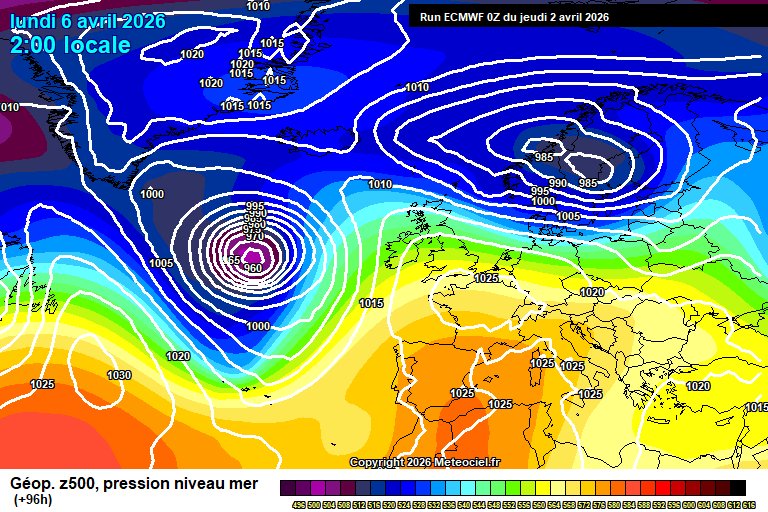
By Thursday we see high pressure trying to build from the south-west, though struggling to dislodge the low pressure to our north-west that much.

Details a bit sketchier from here as it will depend on where exactly weak weather fronts to our north-west are, but more likely Thursday is part-sunny, part-cloud, small chances of showers and a bit warmer, say 17’C or 18’C.

Friday more likely sees a fair amount of cloud but at least some hazy sunshine at times, and around 18’C or so – showers not impossible but more likely dry.

Low confidence for the weekend, Saturday perhaps more likely on the cloudy side with a weak weather front, perhaps a bit of patchy light rain, and around 16’C.

Sunday arguably more likely on the sunnier side, though still with a fair amount of cloud, and still quite warm – around 18’C, perhaps 20’C.

I wouldn’t rule out something warmer and sunnier instead for next weekend.

The only notable signal after that is for it to be generally warmer than normal until at least early May. Rainfall signals are mixed, so expect some showers at times, but I’d suggest more dry days than otherwise.

I’m generally hopeful for often sunny and warm weather in May, and often hot in June.

I remain sceptical of the summer after that with a wetter than normal July and August currently more likely in my view, but it’s a very long way away. I was expected a wetter than normal May a couple of months back and now that seems much less likely…things change. Granted May hasn’t happened!

El Niño is likely to develop also during the summer, though I’m not sure that would have much, if any effect so soon on our weather, given how far away we are from the Pacific Ocean, it’s debatable.

Have a pleasant Sunday, next forecast will either be Wednesday or Thursday morning.…

Thursday 9th April 2026

Cooler weather is on the way, but we’ll squeeze one more warm day first.

We actually reached 25’C here yesterday, and 26.5’C was recorded in Kew Gardens in London…a fair few degrees above what I had expected when I last wrote a forecast.

Thanks to Debbie for the photograph.

So the general set-up sees the warm air hang on over all of western Europe, with low pressure to our north somewhat taking control during the weekend to bring cooler air – but nothing that unsettled.

Thursday starts sunny. Gradually during the morning the cloud will thicken somewhat, remaining generally bright – the odd shower possible from lunchtime through to mid/late afternoon. Reaching around 19’C, give or take, though notably cooling down from mid-afternoon onwards. Some sunshine to end the day. Mostly clear skies overnight, some high cloud later, down to around 3’C.

Friday will be bright with hazy sunshine for much of the day, perhaps the cloud thickening enough for a little light rain/drizzle later in the afternoon. Temperatures back to normal, around 13’C. Mostly cloudy overnight and around 10’C.

Saturday morning will be cloudy as a fairly weak weather front crosses, bringing some rain – probably not very much. Sunny spells will follow for the afternoon, perhaps a passing shower in the wind. Becoming quite windy in the afternoon, roughly around 13’C or so. Mostly clear skies overnight, down to around 5’C.

Low pressure will be closer by Sunday, so sunny spells and a fair few showers likely, some of which could be heavy – a small chance of hail/thunder. Around 13’C or so again, breezy at times – especially in showers. Showers fading in the evening, a chilly night in mostly clear skies – down to around 2’C.

Low pressure moves away on Monday and a ridge of high pressure tries to build.

Some vagueness on details, but broadly some sunshine, some cloud and a chance of some showers popping up – though less likely than Sunday. Around 14’C. A chilly night likely.

Tuesday probably something quite similar, though shower chances diminishing further.

Perhaps a weather front crossing on Wednesday bringing a bit of rain, but uncertain.

The slightly more likely outcome for late next week and into next weekend is a build of high pressure over the continent, stretching into the UK, which would bring at least some sunshine (probably some cloud at times) and something warmer, say in the region of 16’C – 22’C – lower at first but warming up.

Less likely but very plausible would be a condition of the same conditions as before, temperatures roughly in a range of 13’C to 16’C, some weak weather fronts on some days bringing a bit of rain, some sunshine/hazy sunshine on other days.

I’m hoping for the former…oh for warm sunshine to land on a weekend!

There is a signal for warmer than normal weather for the end of April, but the rainfall signal is mixed.

Next full forecast should be Sunday morning.…

Sunday 5th April 2026

Warming up, briefly…after the bank holiday.

Thanks to Tara for the photograph.

The general picture sees the remnants of Storm Dave (which didn’t really affect us down here bar some wind) move away, with a ridge of high pressure moving up from the south-west.

Quite a bit of cloud and a couple of showers around to start on Easter Sunday, but gradually becoming sunnier as the afternoon goes on. Still quite windy though fading later in the day, and only around 12’C so nothing special. Mostly clear skies overnight, some high cloud around towards dawn. A chilly night, down to around 1’C – a touch of frost in places.

Easter Monday will see plenty of sunshine, some cloud around though mostly high-level. We should just about reach 15’C. Clear skies overnight, down to around 5’C.

Tuesday sees long spells of sunshine, just a bit of high cloud around at times in the afternoon. Notably warmer, 18’C for sure, maybe a tad more. Mostly clear skies overnight, down to around 7’C.

The warm air hangs on into Wednesday, long spells of sunshine, a bit more cloud around than Tuesday but still pretty minimal – and generally high-level. 20’C for sure, perhaps getting to 22’C – which would be the warmest day of the year so far. Ohhhh why couldn’t this be two days earlier?! Cloud increases overnight as a weak weather front approaches, down to around 8’C.

By Thursday we probably see this weak weather front crossing, but high pressure just about stays in control.

More likely we see more in the way of cloud and some showery rain but probably some sunny spells at some point. Some uncertainty on details for now – reaching around 13’C though very give and take. A chilly night likely, down to around 4’C.

However there is a smaller chance, say 20%, that the warmth hangs on – and the weather front stays well to our north.

For Friday and into next weekend, we are into a split realm – the more likely outcome is that it stays reasonably dry, often sunny, sometimes cloudy – maybe a weak weather front bringing a little rain or some showers at some point, and temperatures roughly around 15’C.

However, that 20% chance of it staying warm and sunny instead, around 20’C or so, remains.

Dry weather generally seems more likely than wet weather for April as a whole, though some mix of conditions should still be expected.

Enjoy the rest of your Easter weekend.…

Thursday 2nd April 2026

Easter weekend is upon us and broadly speaking it isn’t too bad, a bit of wind and rain, but plenty of useable weather – if not exactly especially warm sunshine.

It’s actually pretty close to my previous “vague and uncertain” forecast I gave.

Also I was quite surprised to see a post by the Met Office calling Easter weekend “very unsettled” the other day…not what I would even class as unsettled, but hey.

Thanks to Fiona for the photograph.

So the general picture right now sees a ridge of high pressure over the southern half of the UK, low pressure systems not far to our north-west and they will have more influence on Friday/Saturday.

Thursday sees plenty of cloud around, especially this morning, but there will be sunny spells at times. Sunshine amounts increasing somewhat in the afternoon. On the cool side, around 11’C. Cloud thickening overnight with some patchy light rain after midnight, becoming breezy, down to around 6’C.

Good Friday will be cloudy to start the day with patchy light rain. During the middle part of the day, likely drier, perhaps some bright/sunny spells, and again cloudier later with some showers possible. Quite windy at times, and around 14’C. Showers fading during the evening, quite cloudy overnight though some clear spells at times, and down to around 7’C.

Saturday starts on the cloudy side, some patchy rain possible – but minimal. Brighter skies in the afternoon with sunny spells and variable amounts of cloud. Becoming windy later in the day, and around 15’C or so. Becoming cloudy overnight – a weather front will cross after midnight bringing an hour or so’s rain, nothing much again. Down to around 6’C once the weather front has passed, mild before.

Easter Sunday should be a reasonably sunny day, some cloud around at times, perhaps a shower or two – though fairly innocuous if you do catch one. Around 12’C and breezy. Chilly overnight in clear skies – down to around 1’C, though give and take so a frost possible.

For Easter Monday we start to see high pressure to our east, which will briefly pull up some warmer air from the south…after Easter.

It should be a reasonably sunny day, some cloud possible at times. Temperatures around 14’C which is pleasant enough for the time of year, if nothing amazing. Clear skies overnight, down to around 5’C.

For Tuesday we probably squeeze a warm and sunny day before weather fronts arrive. Good spells of sunshine, and 20’C should be very feasible, perhaps a tad more. Unlucky timing for those of us going back to work that day!

Some showery rain with more normal temperatures for Tuesday night into Wednesday – again not much in the way of rain.

Perhaps more rain on Thursday.

Not sure where we go after that. I was confident on a dry and settled first half/two-thirds of April but looks like I might be wrong on that, with something more changeable seeming more likely now.

Not particularly seeing anything in the models longer-term other than mixed conditions.

Enjoy your Easter weekend, and the extra days off if they apply to you. Next full forecast probably on Sunday morning.…