Sunday 18th January 2026

Everything’s pretty ordinary on the ground for the week ahead, average temperatures, lots of cloud, a bit of sunshine and some rain. Something colder to follow remains a possibility.

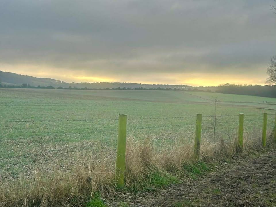
Thanks to Helena, and Gladys for the photograph. Alas, I cannot quite promise this level of sunshine.

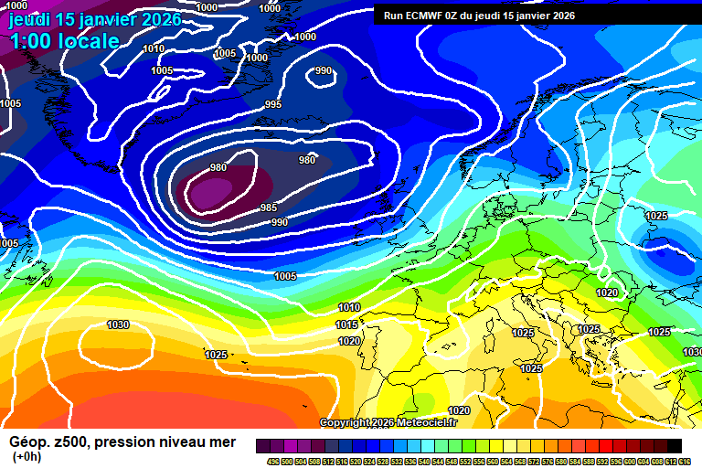
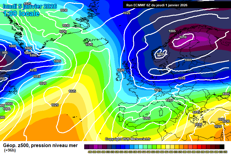
So the general overview sees low pressure systems in the Atlantic not being able to progress that far due to the high pressure block over Europe. We are stuck in the middle.

Low pressure is over Spain/Portugal too, and as low pressure to our west gets closer later in the week, it probably we end up taking a more southerly directly due to the high pressure block.

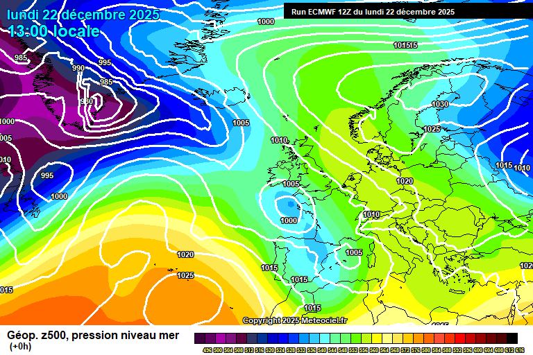
Today has started cloudy, misty – there’s some bits of rain around too. Generally this is the way it will remain, often cloudy, occasional bits of rain – but there should be some bright/sunny spells at times, more so mid/late morning and early afternoon. Fairly mild, around 10’C. Mostly cloudy overnight, some mist/fog patches possible, perhaps a spot of rain at times – but the weather fronts will remain stuck to our west. Around 7’C.

Monday again will be mostly cloudy, some bits and pieces of mostly light rain though often dry. Some bright/sunny spells at times too. Around 10’C, maybe even 11’C. Similar overnight, often cloudy, occasional splashes of rain, around 7’C.

More hope for some sunshine on Tuesday, there will still be a fair amount of cloud at times, and some showery bits of rain will remain very possible. Around 9’C, maybe 10’C, becoming breezier. Showery rain may develop by late afternoon – some uncertainty on this. Showery rain probable in the evening and overnight, around 6’C.

Details a little sketchy for Wednesday, low pressure will be much closer – overnight weather fronts will probably bring some rain at times on Wednesday, more likely in the morning and evening, perhaps some brightness in between. Feeling a tad cooler, around 8’C and breezy. Rain probable in the evening/overnight.

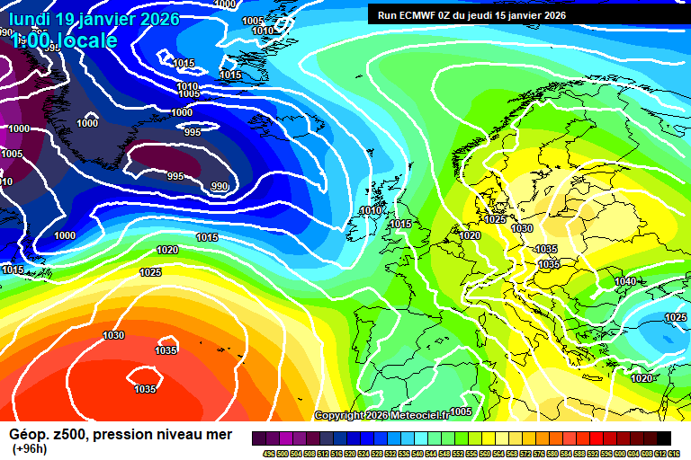
By Thursday those low pressure systems are queueing up, but cannot make much progress due to the huge high pressure block stretching from Siberia – and edging closer to the UK, with associated very cold air.

So the hemispheric view is really interesting, but down on the ground for us, little difference. Thursday is probably a showery day, lots of cloud, a bit of sunshine – showers probably heavy/very heavy – maybe even a rumble of thunder. Around 9’C, and breezy. Showers possible overnight too.

Into Friday, further rain and/or showers are likely – temperatures roughly around 8’C or so.

Next weekend is fairly uncertain, but the more likely outcome is that the low pressure systems start to give up trying to cross the UK, and sink south – allowing a more easterly (ish) flow to set up.

So showers possible still on Saturday, temperatures a tad colder but nothing unusual.

Sunday more likely on the dry side, but perhaps quite cold by this point.

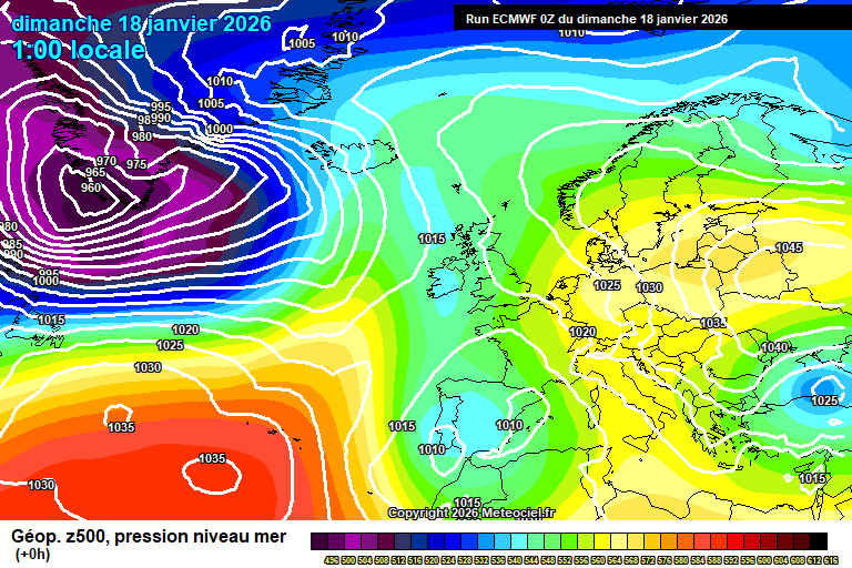
The more likely outcome for the week after would see colder than normal weather, probably fairly dry though wintry showers possible – overnight frost/fog very possible. Not certain that it will go cold, but the more likely outcome by a fair distance. I’d probably say 70/30 cold vs mild in terms of probabilities.

And there remains the small possibility of something notably cold/snowy.

Have a fun Sunday. Not sure when the next forecast will be as Wednesday is office day and Thursday I’m going to Barcelona for the day and that involves a 7am flight…but I will find the time at some point, as it is quite interesting hemispherically right now…even if it might just seem ordinary on the ground here.…

Thursday 15th January 2026

A wet day today, though after that it should be fairly middling, some cloud, some showers, some sunshine. Perhaps more interesting later next week as the high pressure block to our east edges west…

Thanks to Tracy for the photograph.

So the general set-up sees low pressure to the west heading our way, though high pressure over Siberia is going to head west, which will mean that the main low pressure sits over the UK during the weekend, and gradually fades, as it cannot move east.

Today starts cloudy. Outbreaks of often heavy rain will arrive any time from around 8/9am onwards, and will continue until mid-evening. A fair soaking ahead. Around 9’C, winds becoming quite gusty in the afternoon too. Skies gradually clearing somewhat once the rain clears mid, maybe late evening, some mist/fog possible in places – but one or two showers again possible before dawn. Down to around 3’C.

Friday will be brighter to an extent – still a fair amount of cloud around but there will be bright/sunny spells at times, more so in the afternoon. Showers possible, more so both first thing in the morning but possible any time of the day – they will be hit and miss, so an equal chance of staying dry as to catching one/two. Around 9’C and breezy. Fairly cloudy in the evening and overnight, and more in the way of showers around. 7’C or so.

By Saturday the low pressure is fading quickly – quite a lot of cloud around and some showery bits, but a fairly nothing day really, weather-wise. Around 9’C. Generally mostly cloudy overnight – there is a chance of some showery rain moving up from France, but low likelihood – say 20% chance.

Some uncertainty on details for Sunday, though the most likely outcome is a mostly cloudy day with some outbreaks of showery rain developing at some point. But it is quite finely balanced, and a cloudy but dry, or even a fairly sunny day is possible. Around 8’C.

By Monday we are kind of in battle ground scenario, with low pressure systems coming up against the high pressure block to our east, and the UK is roughly where the no entry sign is.

Again details from here are fairly uncertain, and will depend on where weather fronts stall.

For both Monday and Tuesday, the main weather fronts should remain to our west – but likely some showers/showery rain develops ahead of them at times, so generally the more likely outcome is fairly cloudy, occasionally bright/sunny, some showers/showery rain at times – but often dry.

Still around 9’C or so.

Highly uncertain for the rest of next week – maybe low pressure systems make more progress and we get some more rain for a time – but also maybe the high pressure block extends this far west, and we get drier and somewhat colder weather instead, with overnight frosts becoming possible once more, depending on cloud amounts.

There’s a reasonable chance that the week after (w/c 26th January) sees more of an easterly flow, with a return to below-average temperatures, and a chance of wintry showers depending on the exact set-up.

A very long way away, in meteorological terms, but there are fairly strong signals towards this considering it is 12+ days away.

I wouldn’t even rule out a Beast From The East type scenario. It’s within the range of plausible outcomes.

Have a jolly end to the week, I shall be back on Sunday morning, all being well.…

Tuesday 13th January 2026 – Rain Update

Just a little rain update as I left it a tad uncertain on my previous full forecast.

For today, rain arriving around 9am through to around midday/1pm – for the main area of rain anyway, with bits and pieces continuing well until this evening, perhaps the first part of the night as it slowly edges east.

Some rain Wednesday evening, perhaps from late afternoon – but showery.

Then further heavy rain arriving on Thursday morning, arriving around 9am, give or take – and continuing well until the evening – a fair soaking.

All other details as per my full forecast on Sunday, and I will do a full forecast on Thursday morning (hopefully) when I have more time.…

Sunday 11th January 2026

The cold spell is ending, with milder air and some rain at times to replace it. All fairly ordinary.

I’ve had a sudden splurge of photos so thanks for them all, too many to use so as always, do forgive me if I don’t use yours. Thanks to Isabel for this week…yes I do often need cloudy photos!

We still have a fairly slow-moving pattern, with low pressure to the west/north-west and a south-westerly flow picking up – always a mild direction.

Today starts cloudy, the odd spot of light rain around this morning and it’s still cold. From mid/late morning onwards there will be outbreaks of rain, generally light or moderate. Starting the day around 0’C but it will creep up to around 6’C by dusk. Gradually becoming windy too. Some heavier outbreaks of rain around in the evening, temperatures up to a mild 11’C – generally cloudy overnight, the odd spot of rain still possible, and around 9’C.

Monday will generally be rather cloudy – some bright spells at times with some hazy sunshine, a few scattered bits of showery rain possible too at times. Around 10’C and breezy. Mostly cloudy overnight, perhaps some clear spells, around 7’C.

Tuesday remains cloudy and further rain will arrive. Some uncertainty on the track and hence when it will arrive, more likely it arrives in the morning so bringing a wet day – though a smaller chance that it tracks further west, and hence doesn’t arrive until later in the day. But assume the former, for now. Around 10’C and breezy. In either scenario, the rain probably still around in the evening and the first part of the night – but colder air likely arrives for the second half of the night, so a frost possible – down to around 0’C once the rain clears. Perhaps icy, a small chance of some fog patches.

Wednesday sees a ridge of high pressure – sunny to start, gradually clouding over as the day goes on. Colder air in place, around 5’C. A weather front will bring some rain across, either in the evening or overnight.

By Thursday we see the next low pressure system lurking to the west.

Thursday itself is probably a reasonable day, spells of sunshine – if not sunny for most of the day. Around 8’C. A shower possible in the breeze. Rain possible overnight – though quite uncertain.

Details more uncertain by this stage – the general pattern sees the low pressure head towards the UK but weaken as it does.

Showers or showery rain probable on Friday, and possible on Saturday – temperatures around 8’C or so, which is what you’d expect for this time of year.

Dry is the slightly more likely outcome for next Sunday but I really wouldn’t want to promise it quite yet – more weather fronts will be waiting, but also the high pressure block to our east will be trying to push back west.

And that will likely be the story of the weather the week after – how far west can the high pressure block (and associated colder weather) push back west?

Enjoy your Sunday.

Thursday 8th January 2026

Cold with rain at times, but perhaps some sleet/snow falling too – quite a mixed and complex picture.

Thanks to Becky for the photograph – rare I get to use a wintry one, so using whilst it is relevant!

Accurate forecasting period is unusually short at the moment, probably 3 days at best.

So we start the forecast period with cold air still in place, though now in a more mobile westerly flow, with Storm Goretti very quickly developing to our south-west.

Thursday starts cloudy, perhaps with a spot of drizzle. Some brightness possible in the morning before the main area of rain arrives around 1pm give or take, some heavy bursts, perhaps a bit of sleet mixed in but most likely it is all rain. Around 4’C. The main rain clears for a while around mid-evening, though there will still be showers – briefly milder, up to around 9’C. Colder air then tucks in as the low pressure moves east overnight, down to around 2’C – and the back edge of the weather front will cross with a mixture of rain, sleet and wet snow falling. I cannot rule out a light slushy covering, but rain/sleet more likely. Windy at times, notably before and around dawn.

Friday is a cloudy day, with bits and pieces of rain and sleet in the morning, perhaps wet snow if precipitation is heavy enough, gradually easing east. Around 4’C but feeling notably cold in a rather raw wind. Skies should gradually clear overnight, though a fairly close call – it could stay cloudy. Assuming it clears then a frost will form, down to around -1’C.

Saturday looks reasonably bright with sunny spells at times, though also various amounts of cloud too. Around 3’C and breezy – still pretty cold. Clear skies likely at least at first overnight, with a frost – roughly down to around -2’C. A chance of fog forming, perhaps generally clouding over later in the night.

By Sunday we start to see more of a westerly flow pushing across, and signs of something milder too.

Quite a lot of uncertainty over how much resistance the cold air block will have, so the weather front and associated rain (most likely rain, anyway) could arrive in the morning, or maybe not until evening – but the generally trend will be for it to cloud over, with rain arriving at some point, and becoming windier, and slowly, milder.

By Monday we should, should…be back in mild air, say around 11’C or so. Details otherwise uncertain, likely to be some showers around or a spell of rain.

Tuesday similarly mild and uncertain on details – some rain probable at some point.

After that, more likely temperatures are around average or slightly above, with some rain around on some days but also some reasonable spells of dry weather, and hopefully some sunshine at times too.

So I’ve said all this about it returning to milder and somewhat unsettled conditions, but it is still possible that the cold air could hang on instead, maybe it’s a 10% chance. Once Storm Goretti has cleared, things should be clearer in terms of forecasting – it is quite a pivotal low pressure system in terms of what happens afterwards.

Forecasting this last two weeks has been significantly more difficult than normal, and has gone against seasonal expectations – I suspect that the SSW that happened in November is having some effect on both our weather, and the more chaotic output of the weather models that I rely on, which really have been all over the shop at times (my favoured model, the ECM, even had a full-on 1960’s style snow-fest two days ago…which seemed…bizarre).

My assumption is that the upcoming (likely upcoming anyway) spell of fairly unsettled weather won’t last too long, and by the end of January at the latest, we’ll see high pressure having more influence again.

I do feel February, though a mixed month, should see dry and mild conditions dominate somewhat.

Unless…we get another sudden stratospheric warming, in which case we could have more notably cold spells in February. A very possible outcome.

No particular strong signals for early spring (yes I am craving warm sunshine). I’d suggest slightly drier and milder than normal is more likely. There is a signal for something wetter than normal for late spring, though this is 4 months away, so the signal may well fade by time we get closer to May.…

Wednesday 7th January 2026 – Storm Goretti Update

Just a quick update on what has been named Storm Goretti for Thursday/Friday.

Rain will arrive in the afternoon on Thursday, generally pretty heavy – clearing for a time later in the evening as the centre of the low tracks across the south of England, though still some blustery showers around.

In the early hours overnight, the back edge of the rain band will cross, and this could turn to sleet/wet snow – if still heavy enough then there could be a cm of slushy snow by the morning rush hour.

Temperatures varying from 4’C on Thursday, up to 9’C as the low crosses late evening and overnight, then down to around 1’C as the back edge crosses.

It’s still very marginal, it could just be rain on the back edge, it could instead be a bit more snowy, most likely there is at least some sleet/wet snow falling – whether anything would be heavy enough to settle a bit is the more marginal part. So be aware if you have travel plans on Friday morning.

Strong winds also overnight.

Low pressure will struggle to clear east on Friday/Saturday, some bits of rain (maybe even wintry showers) will be possible both days – and it will still be cold, around 3’C.

Sunday night may see a snow-to-rain event – though again it’s marginal, and is way too far in the future right now to have much confidence.

Probably milder and more unsettled next week, but not impossible the cold hangs on instead.

I’ll do a full forecast in the morning, reliable forecasts are 3 days at best right now – and things are marginal enough that the forecast for Thursday/Friday itself could change slightly.…

Sunday 4th January 2026

A few more notably cold days to come, with overnight frosts and a snow shower chance. Then things get complex and uncertain as less cold air tries to push across from the west…

Thanks to Tracy for the photograph.

We start the forecast period with high pressure to our north-west which has allowed cold air to plunge down from the Arctic. Low pressure is much further south over Spain/Portugal.

Today will be mostly sunny but cold, reaching 2’C, maybe 3’C at a push. A little cloud around at times. Some clear spells overnight though also a few light snow showers moving south in the early hours – you may get one, you may not – those places that do will see a slight covering (in mm, not cm) – and likely icy by dawn. Down to around -4’C so frosty for all too.

Monday starts frosty, and icy if you saw a light snow shower overnight. Mostly sunny once more, some cloud at times and a tiny chance of a snow flurry, but very unlikely – and very light if you do catch one. Notably cold, around 1’C. Mostly clear skies overnight and a fairly sharp frost, widely down to around -5’C, give or take. Perhaps one or two fog patches by dawn, but only a small chance.

By Tuesday things start to become messy and more uncertain as a small low pressure crosses Scotland, from the west/north-west. Sunny to start but it will cloud over somewhat, an initial feature may bring a snow shower around lunchtime – very uncertain, maybe a 25% chance. Dry after, some sun, some cloud – a little less cold too at around 3’C. Overnight sees a weather front sink south-east, bringing most likely some rain (temperatures ticking up a tad to around 4’C) but possibly there could be a wintry mix to it.

Wednesday looks mostly bright with spells of sunshine, and varying amounts of high/mid-level cloud around. Still on the cold side, around 3’C. In the evening/overnight another weather front will cross from the west – most likely rain, but possible there is some sleet/snow in the mix, perhaps a snow to rain event, though the emphasis on the rain feels more likely. Temperatures rising to around 5’C overnight, give or take.

That’s about as far as I can go with any confidence on details.

Low pressure systems likely take over from this point, but the track is uncertain, and hence the timing of any bands of rain, and whether they could turn into snow, or feature a snow-to-rain event. Such an outcome is possible for Thursday/Friday and maybe Saturday.

So basically expect rain at some points on Thursday/Friday and Saturday – probably not every day, and expect it to be windy at some point, perhaps very windy. And it might snow instead of rain, at some point.

Impossible to give any more details.

Probably milder by Sunday, but don’t hang your hat on it – everything is highly uncertain from Thursday onwards, if not Tuesday onwards.

Next full forecast should be on Thursday morning, but if it looks probable that there will be a snow event on Thursday/Friday, I will try to do a brief update before then.…

Thursday 1st January 2026

Happy New Year everyone! We start the year with an Arctic plunge, and it will be notably cold, often sunny – and there could be a possible wintry surprise.

Thanks to Debbie for the photograph.

So we start the forecast period with high pressure to our northwest, towards Greenland/Iceland which then allows notably colder air to plunge down from the Arctic.

After a sunny start to New Year’s Day, a very weak weather front will spread south bringing more in the way of cloud, but quite high/mid-level so still generally bright with hazy sunshine most of the time. I cannot totally rule out a light shower, but it should remain dry. Around 6’C and becoming breezier. Fairly clear skies at first overnight, and colder, but a small feature will bring some showery rain/sleet and/or snow down from the north-west in the second half of the night. Some uncertainty on the exact dry, so it could stay dry – more likely something will fall, and it’s such a marginal call, my best guess is that a mixture of rain, sleet and snow will fall during the early hours – don’t be surprised if there is a slight covering of snow when you wake up, but definitely don’t expect it. Down to around 0’C before the feature arrives, around 2’C during. Possibly icy in places too…so do take care if out in the early hours.

Friday sees any early cloud with rain/sleet/snow mixtures clear quickly. There may well be ice and/or a slight covering of snow in places. Mostly sunny after, some bits of cloud around, reaching around 3’C, maybe 4’C – but will feel colder in the northerly breeze. Clear skies and frosty overnight, down to around -3’C.

Saturday starts frosty. It will be a mostly sunny day, some bits of cloud possible – but notably cold in the northerly breeze, around 2’C. The breeze easing overnight which will allow for a sharper frost, easily down to around -4’C quite widely, perhaps lower especially in more sheltered spots.

Sunday starts frosty. Again it will be mostly sunny, but temperatures will struggle to around 2’C at best. I cannot totally rule out a stray snow shower if a feature develops at some point – but feels like a 10% chance at best. Cold and frosty most likely overnight, down to around -4’C, give or take.

By Monday we are still in the Arctic flow, but the high pressure to the north-west will have sunk south, which will allow Atlantic weather systems to start to head our way – or at least try to.

Mostly similar weather, plenty of sunshine, some cloud around at times – and again I cannot totally rule out a wintry shower (more likely snow) if a feature develops and spreads inland, but again a 10% chance at best. Around 2’C. Most likely frosty overnight and down to around -4’C, perhaps lower.

Tuesday should remain cold and sunny, though probably increasingly hazy as a weather front tries to push in from the west. Again around 2’C, perhaps a tad less cold. The weather front might give a bit of light rain and/or snow later in the day or overnight, but highly uncertain.

Notably uncertain after that, currently the more likely outcome is that it becomes a bit less cold for Wednesday/Thursday with some rain around at some point – Thursday itself perhaps quite mild and windy, but as I said, low confidence on details. It could instead stay fairly dry and cold.

The slightly more likely outcome for Friday and next weekend is then colder once more.

Further ahead more likely it becomes fairly changeable, some dry days with overnight frosts/fog, mixed with some wet and windy days. Temperatures balancing out around average.

I wish you all a good 2026 – may we get plenty of warm sunshine again (or whatever your weather preference may be!).…

Monday 29th December 2025

Fairly cold this week, but becoming colder in the new year – there’s even a small chance of snow.

Thanks to Andy for the photograph.

The general picture to start the week sees high pressure to our north-west, we keep the easterly flow though the source isn’t too cold at the moment, so hence nothing especially cold here – the warmer-than-normal North Sea probably also having some moderating influence too.

Monday will be mostly cloudy, some occasional brightness and around 6’C, maybe 7’C in an easterly breeze. Often cloudy overnight though some clear spells, perhaps the odd spot of drizzle also – down to around 3’C.

Tuesday starts mostly cloudy though the cloud should break up somewhat in the afternoon to give more in the way of sunny spells. Perhaps a light shower at some point also. Around 6’C. Some cloudy spells and some clear spells overnight – likely enough clear spells for a frost, and down to around 0’C – but give and take on that. A chance of fog patches by dawn.

New Year’s Eve probably starts sunny, though there is a chance of some morning mist/fog or patches of low cloud. Once any cloud/fog clears then it will remain mostly sunny, just a little bit of cloud around. Colder, around 4’C. Clear skies and frosty at first overnight, down to around -2’C – though cloudier in the second half of the night.

For New Year’s Day, we start to see much colder air spread down from the north.

So mostly we’ll only get cloud from the weather front on New Year’s Day, perhaps a bit of showery rain but more likely it will have all faded by time it gets this far south. Some bright spells probable too. Around 4’C, maybe 5’C and becoming breezier. Some clear spells likely overnight, a frost possible – roughly down to around 0’C.

By Friday there is more uncertainty on details, but broadly speaking a fairly sunny day, some cloud at times – suggestions of a little feature spreading down from the north in the afternoon which would give some showers, perhaps with a wintry mix, but still too early to be sure on this. Feeling colder in the northerly breeze, though still around 4’C. Cold overnight with a frost very likely – it should be down to around -3’C, though some give and take on that. A small chance of a stray snow shower.

Saturday most likely is a cold but sunny day, with only a small chance of a stray snow shower. Around 2’C. However, there is a small chance instead that a weather front spreads up from the south – if it does then a spell of snow would be likely. It’s no more than a 5% or so chance as it stands, but because it would cause disruption, it is worth mentioning – if you have plans, do keep an eye on forecasts. Likely frosty overnight, down to around -3’C, a stray snow shower not impossible.

Sunday again looks cold but mostly sunny – around 2’C. Not impossible that there would be some kind of feature to bring some wintry showers at some point, but impossible to say right now. A sharp frost likely overnight once more.

Next week likely starts cold once more, but probably (with very low confidence), the westerly flow will return and temperatures will recover to normal or just a little below normal – precipitation should then be of rain, though certainly possible that the transition could see some snow mixed in.

Certainly possible that it just remains mostly cold and mostly dry.

So an interesting and cold start to 2026 ahead – I’ll be back on either Thursday/Friday morning, depending on how bad my New Year’s hangover is!…

Monday 22nd December 2025

Mostly dry and becoming somewhat colder for Christmas week.

Thanks to Tracy for the photograph.

So the general overview sees high pressure developing over Scandinavia, with an easterly flow setting up – and the current diminished low pressure moving south.

Tonight will be mostly cloudy, a little light rain/drizzle possible at times, perhaps some mist too. Down to around 7’C.

Tuesday will be dry but cloudy. The easterly breeze starting to make it feel somewhat colder, around 7’C. Remaining cloudy overnight, down to around 4’C.

Christmas Eve should see more in the way of sunshine – still some cloud floating around at times. A bit colder, around 5’C and feeling colder than that in the wind. Skies tending to clear overnight, likely too windy for a frost – down to around 1’C.

Christmas Day should be mostly sunny – but cold. 4’C and fairly windy – so feeling colder than it will register on the thermometer. Perhaps some cloud later in the day – a very, very small chance of a wintry shower but highly unlikely. Some cloud probable overnight, though clear spells also – touch and go on a frost, down to around 0’C but still probably too breezy.

High pressure remains in control for Boxing Day, and the easterly flow remains – though not tapping to anything especially cold over Europe.

It will remain dry for Boxing Day – uncertain on cloud/sunshine amounts, though more likely a mixture of cloudy and sunny spells during the course of the day. A bit less cold, around 5’C and the breeze lessening. Uncertain on cloud amounts overnight – frost possible if skies are clear.

Again Saturday is uncertain on cloud/sunshine amounts – probably a mixture of cloudy and sunny periods once more. Around 6’C. Cloudy spells more likely overnight.

Sunday probably on the cloudier side of the spectrum, though temperatures nudging up a tad more to around 7’C. Still some uncertainty, so I cannot rule out something on the sunnier side of the spectrum.

High pressure likely, if not certainly, remains close by next week.

More likely we’ll keep with the average temperatures and a fair amount of cloud – perhaps some mist/fog at times, possibly some occasional light rain/drizzle.

But there is a small chance instead that high pressure moves further north-west and we get a more northerly flow with some wintry showers. I’d say this is a 20% chance at best, but something to have on your radar if you have plans for New Year.

Probably it stays mostly dry and settled for at least the first week of January, perhaps two weeks.

So I wish you all a very Merry Christmas!

I doubt I’ll do another forecast until next week – thanks to the weather for settling down and being boring, it is appreciated.…