Sunday 14th September 2025

Pretty mixed autumnal weather ahead, some wet days, some dry and sunny days.

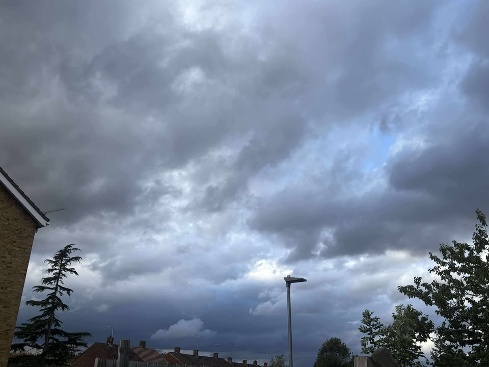
Thanks to Marion for the photograph.

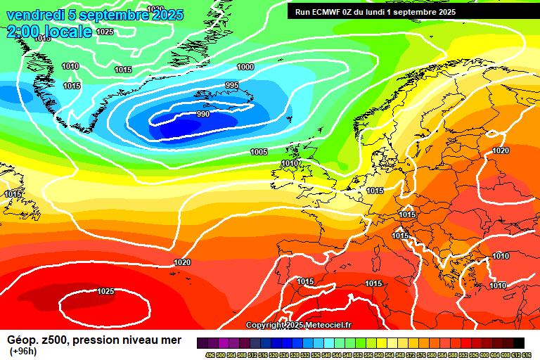
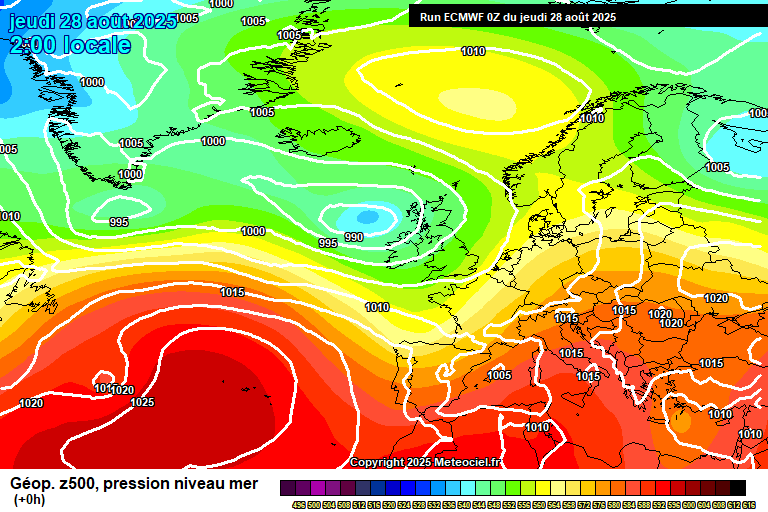
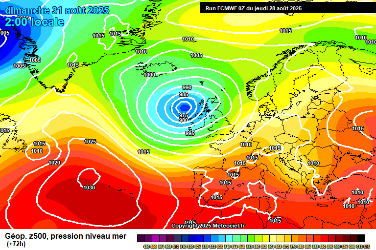
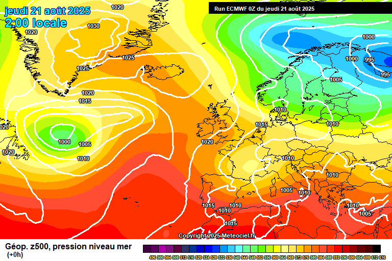
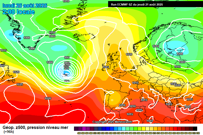
The general picture sees low pressure in charge, to our west though it will now have enough momentum to clear through towards Scandinavia over the coming days. And then we’ll await the next system.

Sunday starts bright but cloud will continue to thicken. Patchy light rain from late morning (ish) onwards, becoming more persistent in the afternoon, and heavier – some very heavy bursts of rain possible late afternoon/early evening, an outside chance of thunder too. Windy, reaching around 18’C. The rain clears around mid evening, variable cloud overnight, perhaps a shower – and the winds becoming rather strong. Down to around 12’C.

Monday’s main story is the wind – gusts of 45mph, perhaps 50mph, may cause some distruption in places – there is a Met Office weather warning out. Otherwise it will be a fairly cloudy day with plenty of showers, some heavy, a small chance of thunder. Some bright/sunny spells but not much. Just about reaching 18’C. Showers fading in the evening and overnight, and the wind gradually becoming less strong – down to around 11’C.

Tuesday is a calmer day as the low pressure system moves away – some sunny spells, some cloud, small chances of light/moderate showers though more likely statying dry. Still breezy, especially in the morning, and reaching around 18’C. Cloud will thicken as the afternoon and evening goes on – outbreaks of rain arriving around mid-evening, light at first, but becoming heavy, perhaps very heavy at times overnight. Around 12’C. Becoming windy too.

Wednesday likely starts cloudy, probably still some rain around. Gradually this should move away to leave some sunny spells – though I have fairly low confidence about this. Some warmer air mixed in, if the sun comes out then 21’C possible, if not then around 18’C. Likely windy.

Thursday…well it could be anything I’m afraid, the only aspect I have confidence on is warmth trying to spread up from the south.

Confidence is fairly low for Friday, but the slightly more likely outcome would be for a warm and sunny day.

Very low confidence on details for next weekend, but the broad picture should see low pressure moving across, and pushing any warmth away.

There’s a small chance of a very warm/quite hot day on Saturday, but it will be a few days until we know with more confidence. Heavy showers will at some point move across – be it on Saturday day/night or Sunday at the latest.

Early signals for the week after suggest something drier and more settled for a time.

Have a pleasant Sunday, time for me to go cure my hangover.…

Thursday 11th September 2025

Showers or rain is the theme.

Thanks to Tara – my most regular rain photographer!

So the general picture sees a large area of low pressure in charge, centred to the north-west of Scotland though stretching from Greenland into western Germany.

Thursday starts bright with some sunny spells, a chance of a shower early on but most of them will be near the coast. From around mid/late morning they will develop inland, they will probably be heavy, possibly very heavy with thunder – most places catching a few during the course of the day, but maybe you’ll miss them all. Quite windy, especially in the showers, reaching around 19’C. Variable amounts of cloud overnight, a very small chance of a shower – down to around 10’C.

Friday again starts bright with sunny spells. Quite a lot of cloud will bubble up during the morning with heavy showers breaking out, again possibly very heavy with thunder, again most places catching a few – but a small chance you’ll miss them all. Remaining quite windy and reaching around 18’C. Showers fading in the evening, but further showers probable overnight. Around 11’C.

Saturday remains in the same broad theme, some sunny spells, quite a lot of cloud and plenty of showers around – perhaps slightly less than the two days before. Again quite windy and reaching around 18’C or so, maybe a tad more. Clear spells overnight though cloud starting to build by dawn, down to around 8’C.

Sunday starts bright, but cloud will continue to thicken and rain will arrive at some point. Some uncertainty on the timing, 8am at the very earliest though I’d favour an arrival time in late morning. So a few hours of rain then follow, some heavy bursts possible, some strong winds probable. Once the main band of rain clears, it will remain generally cloudy with some heavy showers at times – and potentially a squall line crossing in the evening, which if it transpires would bring a short period of very heavy rain and squally winds. 18’C despite all the rain, with some warmer upper air mixed into the system. Further showers likely overnight, strong winds probable.

Low pressure is still very much in charge on Monday.

Strong winds probably the main feature – perhaps gale force, and with trees in full leaf this could cause some disruption – one to watch. Otherwise some sunny spells but plenty of showers, likely heavy. Around 17’C – give or take. Variable amounts of cloud overnight, around 11’C.

Tuesday looks a bit of a calmer day, some sunny spells, probably quite a lot of cloud and some scattered showers – though likely more on the light/moderate side if you do catch one. Around 17’C. Cloud thickening overnight, becoming quite windy and rain arriving at some point.

Wednesday probably sees rain in the morning, uncertain in the afternoon – maybe more likely dry but low confidence. Around 18’C.

That’s about as far as I can go with any confidence.

There’s a chance of something warmer and drier for late next weekend and into next weekend, but I certainly wouldn’t make plans that rely on it – it could very easily remain unsettled. Really is a 50/50 call at the moment.

Generally I expect things to remain pretty changeable, the last third of the month does have the potential for some dry and warm days but I’d be surprised if it was any more than a 3-5 day spell.

Further showers and rain seems like it will be the main theme of the next 4-5 weeks, with just shorter dry/warm/sunny spells. Oh well, sun-seekers like myself have had a great run.

Have a pleasant end to the week.…

Sunday 7th September 2025

Good morning from a boiling hot Travelodge in North London, and we are just squeezing out a very warm day outside too – before we gradually return to something more unsettled by midweek.

Thanks to Christel for the photograph.

So we start with high pressure to our east, low pressure to our west, which is briefly dragging up some warmth.

A sunny start to Sunday, a band of showers will cross later in the morning/around lunchtime – but probably it will fade by time it arrives and your location stays dry, but still a chance of a heavy shower in that period. The afternoon then sees hazy sunshine. Reaching around 25’C or so, though temperatures tailing off a bit in the afternoon, and quite windy too. Reasonably clear skies overnight – I cannot totally rule out a shower, but it should remain dry. Down to around 12’C.

Monday sees good amounts of sunny spells, though some fair-weather cloud will bubble up, and there will be some scattered heavy showers around – say a 40% chance of catching one or two. The warmth will have moved away but we’ll still reach around 21’C, and still breezy. Mostly clear skies overnight, down to around 8’C.

Tuesday again starts sunny. A fair amount of fair-weather cloud will bubble up, again a chance of some showers, say a 30% chance of catching one or two, but otherwise a pleasant day. Pretty warm, 21’C, maybe 22’C and still breezy. Becoming cloudier overnight, perhaps some showers later. Around 13’C.

By Wednesday we start to see weather fronts pushing across – high pressure over Russia is proving more resistent than I previously expected. Some uncertainty on details, but broadly quite cloudy, some sunshine (probably hazy) and some showers or showery rain at some point, more likely afternoon onwards. Still on the warm side, assuming some sunshine then between 21’C and 23’C. Breezy too. Further showers, possibly heavy/very heavy, possible overnight.

By Thursday we start to see low pressure more in control.

Most likely a day of some sunny spells but lots of heavy/very heavy showers – thunder possible too. Around 19’C, so fresher than it has been, and quite windy.

Friday and Saturday likely quite similar in terms of there being plenty of heavy showers.

Maybe something drier and warmer again the week after.

Have a pleasant Sunday…I’ve run out of energy to write any more!…

Autumn Weather Forecast

Hello and welcome to my autumn weather forecast, aimed at Reading/Berkshire area but will be general enough to apply to most of south/central England.

First up, the usual caveats – forecasting further than 5 days ahead is generally difficult, so forecasting for a season is very much experimental and can only be talked about in general terms.

Some of this forecast will be wrong. Hopefully more will be right than wrong – that’s my general aim.

That said, both my spring and summer forecasts have gone broadly very well, I suggested summer might be “one for the ages”, and I feel you could describe it as so – it was the hottest on record, with above-average sunshine and below-average rainfall.

Alas, the autumn forecast looks trickier.

Also, thanks to Amanda for the photograph. I had some stunning photographs sent in, but I didn’t want to use anything with too much sunshine in…for reasons you’ll soon read about!

Background Signals

Background signals tend to not have too much use in autumn, but I’ll cover them briefly.

ENSO is currently neutral, though it looks like we may go into La Niña as autumn goes on, which would tend to increase the chance of westerly/north-westerly flows (some suggestions we may go into a significant El Niño next year, but not sure how reliable this is).

Sea surface temperatures remain well above normal around the UK, so that suggests temperatures are more likely to be above normal – any colder weather from the north would likely be diluted.

The hurricane season is the wildcard – prior to Hurricane Erin’s development, I was expecting a drier and warmer start to autumn, which has clearly been blown out of the water. It really was a game-changing system. Might another major hurricane change our weather patterns again? Who knows.

September

September starts unsettled – a brief dry and warm spell for the first weekend, then back to unsettled with spells of wind and rain for the next week, a chance of a named storm.

Around mid-month, there’s a fairly good chance of high pressure trying to build across from the south-west, so generally drier, sunnier and warmer for a time in the second half of the month, though probably it won’t last too long – with the end of the month more likely to be unsettled, with the potential for notably strong winds/heavy rain.

This does assume no major hurricane developing towards USA and changing our patterns.

Overall I expect somewhat above-average temperatures, around average sunshine amounts and somewhat above-average rainfall.

Confidence level of 60%.

October

October more likely starts on the unsettled side, with further spells of wind and rain, though this likely trends further east – which means into week two (give or take) less rain, but probably quite cloudy and breezy, with winds more likely from the north-west so a cooler direction.

Low confidence, but high pressure to our south may have more influence in the second half of the month, so a drier spell though I’m not currently expecting it to be especially sunny or warm – that would depend on positioning of high pressure.

Overall I expect around average temperatures, somewhat below-average sunshine amounts and somewhat above-average rainfall.

Confidence level of 50%.

November

Currently I expect high pressure to have more influence in November, though probably positioned to our south-west or west, which tends to mean cloudy affairs in late autumn.

So broadly a fairly cloudy month, some sunny days at times, some weather fronts at times will likely bring some rain/wind – those more likely in the first half of the month.

Perhaps a greater chance than normal of colder north-westerly or northerly flows later in the month, if La Niña develops, which would at least mean sunnier weather – some overnight frosts possible too.

Overall I expect slightly above-average temperatures (though perhaps cooler than average by day, milder by night – due to the cloud), below-average sunshine amounts and below-average rainfall.

Confidence level of 50%.

Summary And Early Winter Thoughts

So a pretty mixed autumn seems more likely currently – drier towards the end, wetter towards the beginning.

Confidence levels are lower than they were for my summer forecast – there are some conflicting signals in the long range models I use, and not really much to go on in terms of background signals.

Current thoughts for winter are for dry and mild weather in December, more mixed later in winter, with the best chance of cold/snow being in February. But of course, this will likely change…it is sooooo far away.

Happy autumn!…

Thursday 4th September 2025

Unsettled is the theme but we’ll squeeze out two pleasant days for Friday and Saturday.

Thanks to Isabel for the photograph (and apologies to anyone that I haven’t replied to, more messages than normal, less time than normal!).

We start with low pressure in control, though it’s a fairly fluid situation – weather fronts are moving through fairly quickly now.

Thursday starts with an organised band of very heavy showers crossing, though it will likely have pushed through by time I click the publish button. This is followed by sunshine and scattered heavy showers, though in the afternoon they will generally fade and become lighter – this doesn’t totally rule out the chance of a stray heavy shower by late afternoon, but will be pretty unlikely by then. Temperatures nothing special despite plenty of afternoon sunshine, say 18’C or so. Notably breezy too. Mostly clear skies overnight, down to around 9’C.

Friday sees a ridge of high pressure building, so there will be good sunny spells, though also a fair amount of fair-weather cloud. A 20% chance of a stray shower, though should be non-heavy if you do catch one. Around 21’C. Reasonably clear skies overnight, though some high cloud around – down to around 10’C.

Saturday will be a pleasant day. Lots of high cloud around so the sun will generally be hazy, but it will be warm and reach around 22’C, maybe 23’C. High/mid-level cloud overnight, around 15’C.

By Sunday we see the next low pressure system moving in.

Some uncertainty on details so don’t be surprised if this is a little bit off – but probably starting bright, before a band of heavy showers crosses in the morning (showers, so you may miss them). Probably followed by hazy sunshine and feeling warm, around 23’C but give or take, depending on how much sunshine there is. Still a chance of a shower in the afternoon/evening. Most likely dry overnight, though an outside chance of a thundery shower, around 13’C.

Monday sees low pressure edge closer, broadly speaking the weather will be sunny spells and showers – though nothing especially showery/heavy currently expected. Still on the warm side, maybe squeeze 22’C. A band of showers probably pushes east overnight, becoming windy too.

The more likely outcome for Tuesday sees sunny spells and showers once more, rather breezy and still fairly warm, around 21’C.

Most likely it stays unsettled for the rest of the week, and probably into next weekend, probably trending notably cooler. Don’t be surprised if there is some notably heavy rain and strong winds at some point later next week.

Currently I have no expectation for a return to sunshine and warmth. Maybe this is it? Unless there is a hurricane in the western Atlantic to shake up the pattern once more.

I will try to do the autumn forecast in the next couple of days. Enjoy the warm days whilst you can.

Autumn Photograph Request

Good evening, it’s autumn forecast photograph request time!

Usual rules:

  1. Must feature autumnal weather of some description – there is more than one type of autumn weather, I tend to use what matches the forecast.
  2. Must be the local area.
  3. Can be from any year…as long as it is autumn.
  4. Must be landscape-orientated, ie the width longer than the height. I know plenty of people ignore this when posting on Facebook, which is totally fine, crack on. But I’m not going to use it unless it is landscape-orientated.

Whoever’s photograph I choose will adorn the forecast and also be the cover photograph on Facebook for the next 3 months.

My life is easier if you add them to the Facebook post but you can also e-mail them.

No idea when I will be writing the forecast yet!…

Monday 1st September 2025

Well it’s autumn, and theres a fair amount of wind, rain and showers to contend with this week.

Thanks to Tara for the photograph.

The general theme to start the week sees low pressure in charge, centred close to the west of Scotland – and it will stay roughly in that area as it spins around for a few days.

Monday starts sunny but showers will quickly develop and spread inland, heavy, perhaps very heavy with a small chance of thunder, most places catching a fair few showers during the course of the day – you’d be very lucky if it stays dry in your area. Reaching around 20’C and breezy, especially in showers. Mostly clear skies overnight, though a stray shower possible, down to around 11’C.

Tuesday starts bright/sunny but cloud will quickly arrive with an organised cluster of heavy showers/showery rain. Potentially some torrential downpours mixed in, again a small chance of thunder. More in the way of sunny spells after lunch, though still some scattered heavy/very heavy showers possible. Breezy, and arouund 19’C later in the day. Clear spells at first overnight, but cloud thickening as the night goes on with rain arriving around or a little before dawn – likely heavy/very heavy. Around 14’C.

Wednesday starts cloudy with spells of heavy/very heavy rain. Some uncertainty as to when this clears, perhaps by midday with sunny spells following, but perhaps there is further very heavy rain to come in the afternoon. Strong winds likely, a small chance of gales. Reaching around 20’C, perhaps a little more – quite a humid airmass too. Showers still possible in the evening and overnight – suggestions of a cluster of showers at some point in the second half of the night.

Thursday has uncertainty on details, but broadly the theme will be showery. Arguably the more likely outcome is organised bands/areas of heavy showers in the morning, fewer showers and more sunshine later – though something drier with just a shower or two is possible, likewise something wetter is possible. Roughly around 20’C. Probably dry with clear spells overnight, down to around 11’C.

By Friday we probably see a ridge of high pressure build from the south-west.

So it should be a reasonably pleasant day, some cloud at times, some sunshine at times, and reaching around 21’C. Maybe my rooftop lunch season hasn’t ended.

Saturday should see high pressure hang on, so more dry and probably sunny weather – an outside chance of some fog to start the day. Roughly around 22’C.

Sunday is uncertain. We’ll probably have warmer/hotter air from the continent – somewhere between 23’C and 29’C, but weather fronts will also be pushing in from the west – maybe we can squeeze a warm/hot and fairly sunny day but very, very low confidence.

The more likely outcome to start the next week would see further heavy rain/showers.

Fairly good chances of returning to settled and fairly warm conditions for the second half of September.

There will be an autumn forecast coming up soon…though as I’ve just got back from holiday and have lots of life and work to catch up on, I’ve no idea when I’ll get chance. Enjoy the downpours!…

Thursday 28th August 2025

Hello from Helsinki! Low pressure is back so rain and showers is the theme, though still on the warm side – certainly warmer than in Helsinki.

I’m on holiday so less looking at weather models than normal, so there is a bit less data in my head to go from.

Thanks to Karen for the photograph.

The general overview sees low pressure (ex-Hurricane Erin, I think) approaching, which will kind of spin around our shores for a few days.

Thursday starts fairly sunny but cloud will soon bubble up with heavy showers breaking out widely – most likely you’ll catch a few during the day, some heavy/very heavy downpours possible, a small chance of thunder. Reaching around 20’C and notably breezy in the showers. Most of the showers fade in the evening, but still one or two possible overnight, down to around 13’C.

Friday looks like it will start with a cluster of heavy showers, or perhaps just general heavy rain. This will clear during the morning to be followed by sunny spells and scattered heavy/very heavy showers. Breezy at times, reaching around 21’C. Clear skies overnight, down to around 13’C.

Saturday starts sunny and dry. Cloud will gradually thicken from the west with outbreaks of rain arriving at some point in the afternoon, maybe early evening at the latest. Around 6 hours of showery rain once it arrives. Reaching around 23’C before the rain arrives – becoming quite windy by the afternoon. Skies clearing overnight once the rain clears, down to around 14’C.

By Sunday the same low pressure will still be centred in a similar position, just to the west of Scotland.

A windy day ensues, with some sunny spells and perhaps some scattered showers – though some uncertainty on the showers, certainly plausible that we stay dry here. Reaching around 22’C. Showers possible overnight.

Monday looks like sunny spells and heavy/very heavy showers, perhaps with thunder. Temperatures a tad lower, say around 19’C.

Most likely then a few more days of either sunshine and heavy showers, or general areas of rain.

Possible that it becomes drier for the weekend, certainly some signs pointing to the drier and more settled weather returning either for next weekend or week two onwards of September, though a long way away meteorologically.

Have a pleasant weekend, I need to go explore Helsinki!…

Sunday 24th August 2025

Often sunny and very warm to start, though gradually becoming more unsettled and less warm as next week goes on, as ex-Hurricane Erin slowly grinds her way through. She’s a pattern-changer.

Thanks to Tracy for the photograph.

So we start the forecast period with high pressure in control – ex-Hurricane Erin in the western part of the Atlantic Ocean.

Sunday starts sunny. Quite a lot bubbling up through the middle part of the day, likely more cloud than sun for a fair amount of time – though breaking up later in the day, with more sunny spells. Warm, just about squeezing 24’C. Mostly clear skies overnight, down to around 12’C.

Bank Holiday Monday looks glorious – long spells of sunshine, a little high cloud in the afternoon and very warm, reaching around 26’C. Clear skies for much of the night, though cloud increasing towards dawn. A warmer night, down to around 16’C.

Tuesday morning sees the first of the weather fronts crossing. Some uncertainty, but a couple of hours of heavy, showery rain is probable at some point in the morning – perhaps it all fizzles out by time it gets here, but more likely there is some showery rain. Sunny spells and fair-weather cloud follow for the afternoon, a small chance of a shower, and still very warm – just about getting to 26’C again, or a shade under. Some cloud, some clear spells overnight, down to around 13’C.

By Wednesday, ex-Hurricane Erin hasn’t really moved much over the last day or so, but starts to track towards us.

Probably Wednesday starts sunny, but cloud will bubble up in the morning, perhaps a shower. In the afternoon/evening, timing uncertain, a weather front will push across. No guarantee of any rain/showers, it may all fizzle out as it struggles to cross – but probably there will be at least some showery rain, at some point, perhaps heavy, and outside chance of thunder. Still on the warm side and probably a bit humid, around 23’C.

Lower confidence for Thursday, but the more likely general theme is fairly dry in the morning, some sunny spells some cloud – chance of showers increasing as the day goes on. Still warm.

Friday and Saturday look fairly unsettled, either showers or longer spells of rain, potentially heavy/very heavy, an outside chance of thunder. Broadly around 20’C, unless it rains all day.

Sunday perhaps sees less showers, though this is stated with very low confidence.

The more likely outcome for the next week would be further low pressure systems bringing more wind and rain at times.

Perhaps improving for the second week of September, but very low confidence – as is normal for this time of year when hurricane season is in full flow.

So enjoy the rest of the bank holiday weekend. I’m off back on my adventures, starting in Tallin where the weather is going to be…15’C and wet.

Next full forecast will depend on what free time I get during my travels, but hopefully either on Wednesday or Thursday.…

Thursday 21st August 2025

Staying mostly dry for now, but often rather cloudy.

Thanks to Andy for the photograph.

So the general picture sees high pressure in control still, centred towards Iceland and also building in from the south-west, though it does mean a north-easterly breeze, which means yet more cloud. And it has taken longer to clear each day than I expected, so far this week.

Today will be mostly cloudy, if anything the cloud will thicken from where we are now, perhaps a spot of drizzle at times. That said, some sunny breaks are possible, more so late in the day. Struggling to reach 20’C in the north-easterly breeze. Mostly cloudy overnight, down to around 12’C.

Friday again sees plenty of cloud. Some uncertainty over how much, and there is some hope for at least some sunny spells, if not some reasonable spells of sunshine – I think more likely in the morning. A small chance of a light shower. Around 22’C with a bit of sunshine. Fairly cloudy overnight, a spot of light rain possible, down to around 13’C.

Saturday sees high pressure more solidly in control, but there’s lot of cloud still trapped under it. So, most likely a mostly cloudy day, though some sunny breaks possible – more likely early and later in the day. Around 21’C, give or take. Further cloud likely overnight, down to around 13’C.

For Sunday, the cloud should break up more readily, so there will be some reasonable sunny spells, but still a fair amount of cloud floating around. Warmer, around 23’C or so. Fairly clear skies overnight, down to around 11’C.

For Bank Holiday Monday, we see high pressure in control, but ex-Hurricane Erin approaching, which looks like she is going to change our weather, although the exact track and patterns not yet sure.

So Monday should be the best day of the extended weekend, good spells of sunshine, some cloud bubbling up, and notably warmer though with some uncertainty, anywhere between 24’C and 28’C more likely. Clear skies overnight, down to around 12’C, give or take.

Tuesday could be quite hot, though weather fronts will be starting to make their way in, so some showery bits of rain possible later in the day. Some uncertainty on this.

Wednesday maybe stays dry or mostly dry, then we should become more showery after this.

Lots of uncertainty from here due to the forecast now relying on the track of ex-hurricane Erin, plus I’ve rushed this forecast a bit as I woke up late!

The more likely outcome for the start of September is that it will be unsettled with showers/rain at times. Oh well…I enjoyed summer, and I hope you did too.…